
Coordinates New York, USA. This trip to the Midwest of the United States has a total of eight days. I went with my parents. On the way, I passed Grand Teton National Park (Grand Teton National Park), Yellowstone National Park, Salt Lake City, Arches National Park, Antelope Canyon, and Horseshoe Bend. The weather in Huangshi has a large temperature difference between morning and evening. If the weather is good during the day, it will be very sunny, and the temperature will be above 20 degrees Celsius; when it is cloudy or rainy, it will be very cold, around 10 degrees Celsius to 15 degrees Celsius, just wear a thick coat. yellowstone The climate is also very unstable. When we went there in June, it also caught up with the snow. The temperature was only 4 degrees Celsius on the snowy day, so we wore windproof jackets. In the eight days in the west, except for a few days of rain and snow in Yellowstone, it was very sunny at other times, so you should bring sunscreen. It is said that there are many mosquitoes in Huangshi, but we have not felt it in the past few days, and the mosquito repellent we brought has not been used.
6/10: Fly from New York to Salt Lake City
The main purpose of this trip is to go to Huangshi, so I did a lot of homework about Huangshi, including where to land by plane. There are also some small airports near Yellowstone, but the prices of air tickets are not very cheap, so I chose Salt Lake City -The classic route of Grand Teton – Yellowstone, and you can also visit Salt Lake City. But time is not enough or I just want to visit Yellowstone Friends. I can choose the entry and exit point is Bozeman Airport, which is 1.5 hours away from the North Exit, which can save a lot of time.
Since we went to Salt Lake City , we chose the Advantage-Rent-A-Car, which is closer to the Salt Lake City Airport, as a car rental company, and then drove all the way to Yellowstone . You can pass a Walmart on the way, the address is 350 Hope Ave, Salt Lake City, UT 84115.
Because there is a supermarket, you don’t need to bring too much food when preparing in advance, you can get off the plane and go to Wal-Mart to purchase it, and it is recommended that you buy all the food and emergency items you need in the park, because you can see it in Yellowstone. There is no supermarket anymore.

6/11: Jackson – Yellowstone National Park
The previous day was the prelude to the journey, and the next day was the official start of the journey. Depart from the hotel early in the morning and pass through the Antler Park in the center of the town on the way.
Antler Park is the most famous attraction in the town of Jackson. It is said to be a park, but it is actually a small open space with four gates, east, west, north, south, and each gate has a gate made of antlers, so it is called antler park. Antlers are real, but not from killing a deer. Because every winter, a large number of elk come to Jackson ‘s “National Elk Sanctuary” for the winter. After the elk leave, they leave their antlers that fall off naturally, so there is an antler arch.
After leaving Antler Arch, we came to Grand Teton National Park (Grand Teton National Park). Grand Teton has two lines, one east line and one west line. The east line looks at the snow-capped mountains, and the west line looks at scenic spots. So we decided to go to the east to see the snow-capped mountains first.
Because we will come again on the fifth day, we didn’t have too many stops in Grand Teton , and went directly to Yellowstone . Yellowstone Park is in the shape of a horoscope, and we completed the horoscope in three days. Each day’s route is planned in advance. yellowstone The car inside is easy to drive, except that there is a part of the winding mountain road in the north that is a bit dangerous against the cliff, and the road is also easy to walk. Basically, a main road runs through the entire park, but there are also some small roads that can be seen. A sign says xxx Drive. It can also be seen on the map as a black line a little thinner than the main road. You can see some creeks or small waterfalls when you walk along the path. Although they are not as famous as the scenic spots, they also have a special flavor. Some drives also have picnic spots for picnics.
On the first day of Yellowstone , we entered from the south gate, taking the route of Old Faithful Geyser-Black Sand Basin-Biscuit Basin-Colorful Pot Fountain. Various geysers and hot springs are the geological characteristics of Yellowstone. For the first time It is indeed spectacular to look at, but if you look at it too much, you will feel a little aesthetically tired. Instead, you think that sometimes a random place on the side of the road will look better. And you can smell the sulfur in these springs from a long distance, a bit like the smell of rotten eggs. It was raining when we went, and the temperature difference between the hot springs and the air was large, which produced a lot of fog that shrouded the hot springs, so many springs could not be seen clearly. Friends who are short on time can choose to play, and don’t like to go to some places that don’t like to see hot springs. Here is what I went to Yellowstone I read a strategy before, where it is worth writing is very clear, for your reference.

6/12~6/13: Yellowstone Park
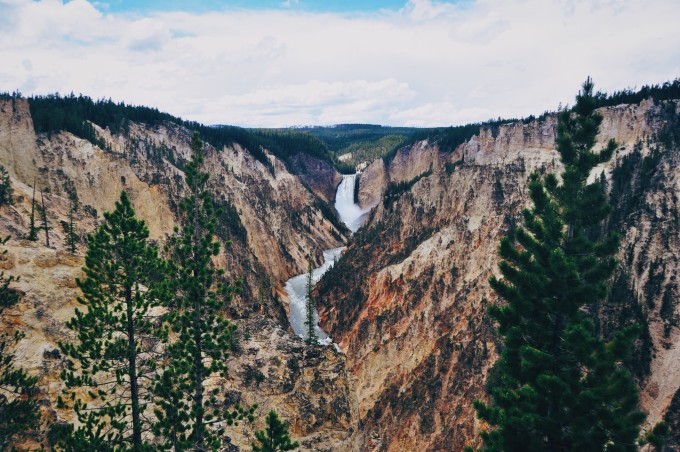
The second day in Yellowstone was a rare sunny day. We originally planned to go to the Mammoth Hot Springs area first, and we decided to go to the Grand Canyon first, taking the route of Norris Geyser- Yellowstone Canyon-Tall Waterfall-Rama Plain.
An unknown plain on the side of the road, with the snow-capped mountains in the distance and wild yaks dotted, is very beautiful.
On the way to the Rama Plain, the speed of the car here is very slow on the narrow winding mountain road.
On the third day of Huangshi , it was snowing, it was snowing in June! When I woke up in the morning and looked out from the hotel window, it was all white, and the trees were covered with snow, which was very beautiful.
The third day was the last day we lived in Yellowstone . The route we chose was Mammoth Hot Springs – Hayden Valley – Fishing Bridge (just a bridge, nothing special to see) – West Thumb Geyser area. In fact, some scenic spots will be repeated in the route we take, but our whole family agrees that the scenery on the road in Huangshili is better than the hot springs in the scenic spots, so we prefer to spend more time on the road, but leave little time to see the hot springs.
Yellowstone Animals in addition to the strange geological features and beautiful scenery, Yellowstone is most famous for its wild animals. When you come to Yellowstone , whether you are lucky or not, one of the animals you will definitely see is the wild yak (Bison). In addition to wild yaks, you may also see various deer, most of which are the most common deer. If you are lucky, you may also see elk and moose. Then there are black bears. There are quite a lot of black bears in the park. They are usually seen in places with few people and many trees. The park also stipulates that each climber must be equipped with bear spray just in case, but I don’t think it’s necessary to buy it when driving. This, because it will be far away. Foxes can also be seen in the park, but they are not easy to photograph because of their small size and quick movements. We saw almost all the animals this time. The only thing we didn’t see was the wolf. I heard that you can see it near the Rama Plain at night, but only at night.
On the first day I went, I was super lucky to meet a herd of wild yaks crossing the road, and it was right in front of us. I heard that the only traffic jam in Huangshi is when animals cross the road, because there is only one main road in Huangshi, and their pace is very slow, and they don’t pay attention to the long queue behind them. We were the first car, and we were able to get close to the yaks in the traffic jam, but the cars behind were not so lucky, and we couldn’t see what was going on in front of the traffic jam.
This is where animals can be seen on the brochure provided by the Yellowstone ticket office, but the actual situation will change due to weather and seasons, for your reference only.
Although it is exciting to see animals, everyone should pay attention to safety while taking pictures and viewing. The park stipulates to keep a distance of at least 91 meters from bears and wolves, and a distance of at least 23 meters from other animals. After all, safety is the most important thing when going out. Everyone must abide by the rules of the park and don’t do it just to take good photos wrong behavior.
This is the end of the Yellowstone part! After three days, we have plenty of time every day. We set off at 8:30 in the morning, arrive at our place of residence before dark at night, and have time to visit unplanned attractions. For Huangshi , I think that if it is not an in-depth tour, three days of self-driving tour is more than enough. Two days will be a bit urgent but there is still time. If it is more than three days, you should be able to play more detailed. Another reason why we can play a lot in three days this time is that we have done enough homework before we go, and we have also made a relatively detailed travel plan. Which route to take on which day and which hotel to stay in are all determined in advance, so we have fun. Time will not be rushed. Therefore, before departure, everyone can make a plan according to their own time, and know where they will go on a certain day, so that they will not be in a hurry when they are playing.

6/14: Grand Teton West – Salt Lake City
After the Yellowstone trip, we arrived at Grand Teton Park early the next morning. Because we took the east route when we came, this time we decided to take the west route, the Grand Teton Park is easy to walk, as long as you follow the map, you can basically go wrong. But after seeing so many magnificent views of Yellowstone, the Grand Teton The scenery is much inferior. After seeing a few rivers and a few small waterfalls, we left and headed towards Salt Lake City .
The journey from Grand Teton to Salt Lake City is 5 hours. When we arrived in Salt Lake City, it was evening, so we didn’t go anywhere. We went to the hotel to rest for one night to prepare for the next day’s itinerary.

6/15: Salt Lake City – Gateway Arch National Park
It takes about three and a half hours from Salt Lake City to the Arch. In order to catch up with the best noon time for taking pictures, we set off early in the morning.
The Great Arch National Park is much smaller than Yellowstone . If you have been in the car and don’t plan to hike, you can go shopping in about half a day. But if you want to appreciate the real scenery, many scenic spots need to get out of the car, bring your equipment, and walk for an hour or two to see the trail.
The places marked in Chinese on the map are the places I think Arches National Park must see, no matter how fast the time is, you should go there.
Since the park is not big, after getting the map, I suggest that you go to see every scenic spot, and then decide whether to get off the car and take the trail according to your interests and physical condition. If you don’t want to take the trail, you can go to the viewpoint viewing platform.
Balanced Rock (Balanced Rock), 39 meters high, the balance rock on the top of the rock is equivalent to the size of three school buses. It is one of the ten most amazing natural balance stones in the world.
After seeing several large and small stone groups, we went directly to the Delicate Arch. Delicate Arch is the most famous arch in the entire park, and it is also a landmark of Utah , and the license plate of Utah is also printed with Delicate Arch.
There are two ways to see the Delicate Arch. One is to walk along the trail for an hour under the scorching sun (two hours back and forth), and the other is to walk around the map to the Delicate Arch Viewpoint to take a long, long look at the viewing platform. We were hesitant at first, because we don’t usually exercise too much because we are afraid that our bodies will not be able to bear it. But after taking a look at the viewing platform, we found that it was really too far away, and we could only see a very small figure of the arch. In the end we decided to get off the bus and take the trail.
At the entrance of the trail, you can see a big sign reminding everyone that the temperature is very high, so bring more water. Our family of three brought a total of 7 bottles of water and a bottle of Coke. After two walks, we finished them all. It is recommended that you do not bring cola, as the cold cola will become warm within a few steps, and it will not quench your thirst.
And if you want to take the trail, you must wear more sunscreen! ! Try to apply it thicker, and it is best to carry a bottle in your bag to reapply, because it is really too hot, and there is no shade all the way. I was wearing a long skirt so I didn’t wipe my legs, and when I came back, my calves were red from the sun. Wear as comfortable clothes as possible, especially a pair of comfortable shoes. The trail is only a man-made path at the beginning, and there are some natural paths in the back, which is not easy to walk.
Small stone piles piled by people on the side of the road to identify the way.
After the first ten minutes of walking, the road starts to be difficult to walk, and you may not even find the road in the middle. You can only identify it by looking at the small road signs and some small stone piles piled up by people on the roadside.
When we went this time, there were quite a lot of people. We occasionally saw a few people coming back from the arch along the way. Everyone was very friendly and would greet each other. Some people would encourage you to tell you when you were tired. ‘re almost there! When you are about to walk, you will see a narrow path with a cliff next to it. Although the road is very narrow and it seems difficult to walk, but seeing this road means that you have arrived! Turning over the hill, you can see a particularly empty sky. The most conspicuous place is the huge arch, which is beautiful. The stumbling, hard work and sweat all the way are gone at this moment. It feels like walking for so long to see everything is worth it.
I wore a long skirt on a whim that day. I suggest that if you want to see the delicate arches, don’t wear it like this…I was so stupid to lift the skirt all the way.
Although the way to go and come back is the same way, I feel much faster and less tired when I come back.
On the day we went, the entire area of Devil’s Garden was under construction. We couldn’t make it, and we didn’t see the scenic arch. It’s a little regretful, but it’s satisfying to see the delicate arch after all the hard work!

6/16: Horseshoe Bend + Antelope Canyon
The journey from Horseshoe Bend to Antelope Canyon is 30 minutes. When choosing to go to the Upper Antelope Canyon or the Lower Antelope Canyon, there are a few points to note: there are more people in the Upper Antelope Canyon and you may need to make an appointment in advance. If you want to take a photo of a meter of sunshine, you will have higher requirements for light. It is most suitable to go at noon ;There are few people in the Lower Antelope Canyon, no need to make an appointment, but because it is underground, you can’t see the scenery of one meter of sunlight, and you have to climb a relatively steep staircase (because it is relatively steep, the guide will tell you that you cannot take pictures when walking the stairs, but As long as you pay attention to your feet, there will be no danger, and the elderly can accept it), but the scenery is also beautiful.
Antelope Canyon is in Peggy ‘s Indian Reserve. If you want to enter, you must follow the local Indian guide. You can make an appointment online in advance, or you can register when you arrive. We went to the Lower Antelope Canyon. There are two tours in the Lower Antelope Canyon, one is Ken’s tour and the other is Dixie Ellis’s tour. The content of the two tours should be similar.
Antelope Canyon is really beautiful. Before you come here, you must clean up the memory of your mobile phone. You will definitely take a lot of shots when you enter it, because just taking a casual photo with your mobile phone is already very good. The pictures above were all taken with an iPhone 6. Here is a little trick for those who use iPhones to take pictures in Antelope Canyon. It was also taught to me by the tour guide, that is, to adjust the filter before taking pictures. After opening the camera interface, first click the filter button in the upper right corner and select the option of chrome yellow. The photos taken in this way are extremely saturated and do not require post-processing at all. The effect is as shown above.

6/17: Downtown Salt Lake City
Salt Lake City is considered a transit point for our journey. We stopped here three times in total, and only visited the city center on the last day. Salt Lake City is located at the foot of the snow-capped mountains. Compared with the places we have been to these days, it can be said to be quite modern, but it is not as ostentatious as New York. People in the city work diligently and keep their feet on the ground every day. The life here is warm and friendly to people, and it is a very stable small town.
Salt Lake City can visit attractions such as the Great Salt Lake, the Mormon Temple, and the Parliament Building. Because I have read the guide before, I know that the scenery of the Great Salt Lake is not as brilliant as imagined, and there will be a lot of mosquitoes in summer, and there will be a bad smell on the lake, so we did not choose to go to the Great Salt Lake, but went directly to the city center . Salt Lake City is small, and all of its attractions are conveniently located in and around Temple Square.
When you enter Temple Square, you will see many volunteers distributing maps. On the back of the map are introductions to various attractions, which is very convenient and has a Chinese version.
When I went there, it happened to coincide with the weddings of several couples, so there were a lot of people, and everyone took pictures in front of the Salt Lake Temple.
Congress Center is opposite the Temple Square. Once you enter the door, a staff member will receive you and assign you a free tour guide. It seems that the tour guide must take you in. The tour guide is very enthusiastic and will take you to visit the world’s largest auditorium and roof garden. The roof garden is also beautiful, with the parliament building in the distance, and there are nine pyramid-shaped skylights in the center, which allow natural light to shine into the auditorium during the day.
Salt Lake City is the last attraction this time . After visiting Salt Lake City, my parents returned to New York , and I continued to go west for my trip to the West Coast~

postscript
The United States is a vast country, and there are many national address parks in the Midwest, most of which are worth seeing. Because after leaving Salt Lake City , I went to Los Angeles and San Francisco on the west coast , and then I had to rush back to attend the high school graduation ceremony, so my time was limited, and I didn’t go to many places like Monument Valley and Death Valley. If you have enough time, you can plan well and strive to explore this land.
This is my first time writing a travelogue, I hope you enjoy reading it and gain something~