
Fifth day 7/13 Monday Antelope Canyon/BRYCE/Route 12/ TORREY 5 hours and 32 minutes 465 kilometers.
Original plan:
- 9:30-12:30 Antelope Canyon tour
- 12:30-2:30 Antelope Canyon- ZION 1 hour and 46 minutes (168 kilometers)
- 3:30-5:30 Bryce BRYCE 1 hour and 20 minutes (116 kilometers)
- 14 minutes 16.2 kilometers TROPIC Highway 12 marked with GPS
5 .6:30-9: 00 TORREY 2 hours and 12 minutes (165 kilometers)
TORREY Hotel: Broken Spur Inn & Steakhouse
Addr.: 955 East SR – 24 Torrey (Utah), UT 84775
Dinner: The hotel where you live is making steak before 8:30 p.m.

There are several travel agencies in the town that go to Antelope Canyon. It is best to make an appointment in advance to confirm, because in this scenic spot controlled by Indians, there are a total of 4-5 travel agencies that take Antelope Canyon tours, and they are all Indians. It’s easy to get confused if you’re not careful.
It takes less than 30 minutes to drive from the town to the Antelope Canyon Scenic Area (30 kilometers away). This kind of convertible car, with 16 people in one car (8 people on one side), and one tour guide in one car, becomes a tourist team.
Antelope Canyon enters from the crack in the upper right corner of the picture above. At the entrance, the cars of different travel agencies have different colors, and they are neatly arranged in a row. We were greeted by a burly Indian tour guide about 2 meters tall, not to mention kind and humorous. Thanks to the large number of Chinese tourists before, although there are members from various countries in our team, he can speak a lot of Mandarin throughout the trip, which flattered the six of us.

This is a photo of Google Maps of Antelope Canyon. The sunlight is scattered into the valley through the cracks in the picture. To see the wonderful light and shadow in the valley, it is best at noon or when there is plenty of sunshine. We considered the arrangement of the entire itinerary, and reported the ordinary group at 9 o’clock in the morning that day. If you are a big photographer and bring a tripod, it is best to report to the photography group around 12 noon. Ordinary groups usually stop at the place where the tour guide instructed them to stop and take pictures. There are too many people and no tripods are allowed. The photography group takes half an hour longer than the ordinary group. The time of the photography group is when the sun is at its best at noon.
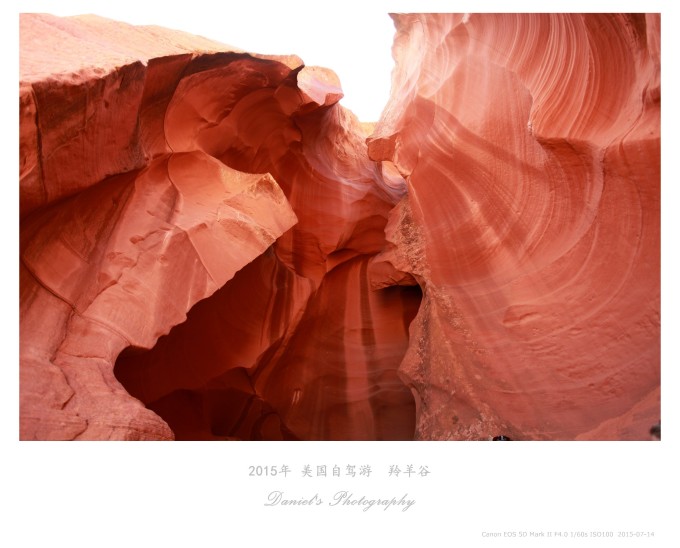
Entering the valley, set the camera to cloudy mode, adjust the sensitivity to automatic, and leave the rest to the unpredictable sunshine. We have always been very lucky. Even though the report is a morning tour, the sun is not stingy at all, and it is very kind. The wonderful light and shadow in the valley. The six of us, whether it is a professional camera or an iPhone, have taken very beautiful pictures.
In order to make the shining beam of light more obvious, the tour guide grabbed a handful of yellow sand and sprinkled it on the beam of light (taken by a small camera SONY black card).
Without a careful guide, this unique stone shape would pass by in a flash. It is difficult for this burly man to help us squat down and take a blind photo before taking this strange photo.
The Indian tour guide, well-informed, suddenly popped out the sound of “longan”. At first, he was a little surprised, but later he realized that he was speaking Chinese.
The flood in Colorado washed out this dreamlike and peculiar structure, and the illumination of light and shadow made the strange structure form an underground light and shadow paradise.
When we saw this piece of red sandstone, we had reached the other end of the valley. Our entire team returned the same way. We could not stop and take pictures when we returned, because this is a place where Indians (Navajo) and the Holy Spirit communicated. On the way back, I put down the camera and struck the red rock all the way back to the entrance, hoping to get the blessing of the Holy Spirit through touching.

After visiting Antelope Canyon, various travel agencies left one after another, and the convoy raised the rolling yellow sand in the yellow sand field, which has the momentum of a western blockbuster.
Afterwards, according to the original plan, I made a detour to ZION National Park before going to Bryce, but I felt that there was not enough time. In addition to the famous THE WAVE and the professional rock climbing in the park, I think this place is still waiting for the lottery to go to WAVE. Finally, let’s prepare again alone, so we headed directly to Bryce.
Bryce Canyon National Park is located in the southwestern part of Utah, USA. Although its name has the word canyon, it is not a real canyon, but a huge natural amphitheater formed by erosion along the east side of the Ponshagunt Plateau. Its unique geological formations, called hoodoos, are formed by wind, water and ice erosion from rivers, and sedimentary rocks from the lake bed. The red, orange and white rocks inside form a unique natural landscape, so it is known as the palace of natural stone figurines.
The essence is in the area just entering the park. After entering the park, drive south about 5 kilometers, this is the best area to watch the stone pillars. There are 4 viewpoints concentrated in this area, namely Sunrise Point, Sunset Point, Inspiration Point and Bryce Point. These 4 viewing points are connected by plank roads, connecting the 4 points into a semi-arc, which just surrounds Bryce Canyon, which is the core area of the entire park.
We drove to admire the magnificent Bryce Canyon at several different viewpoints. . . wait for next time on foot.
After leaving Bryce, from here I will introduce today’s unexpected surprise — Highway 12. When I went to the United States to do a strategy, I knew that travel friends all over the world called American Highway 1 the most beautiful road, and the United States The most beautiful highway selected by domestic people is Highway 12. However, this Route 12 was rarely introduced in travel notes before, or, because of the magnificence and changeability of this road, you no longer know how to introduce the scenery of this road with a camera, which makes its reputation less than that of Route 1 , and when you actually drive on this road, you will be completely shocked. This road may only be GOPRO, or you may only feel it when you are on the scene.
This is the starting map of Highway 12. From Panguige to TORREY, you need to take Highway 12 to Capitol Reef or Arch. Pay special attention to setting the navigation. I set it up segment by segment. For example , when you come out of Bryce, navigate to TROPIC. . . Otherwise, the navigation will directly lead to the high-speed Highway 22 according to the grade of the road. .
Don’t be confused by the picture behind me, thinking that Highway 12 is like this. In fact, facing Highway 12, when you pick up the camera, you will feel powerless. You don’t know how to use the camera to introduce the majesty in front of you to others. , that kind of heart-breaking (perhaps, many self-driving tours to Tibet always say that the most beautiful scenery of Tibet tour is not in Tibet, but on the road in Tibet, but on this road, people who can only drive themselves have experience. The pictures they take are still pictures of Tibet, and they are full of spectacular scenery on the road that is too late to shoot or can’t take pictures). When I stopped the car and faced the scenery, I said, this area, it seems that God wants to carefully plan a beautiful and spectacular place here that includes all the terrains of the earth, but it seems that half of it has been done, and the work has stopped.

There are also cars driving on the back of the mountain. There is no protection on both sides of the road, but the open space under the high mountain.
Cattle, sheep and deer appear from time to time in the woods and meadows.
When we were about to arrive at TORREY, it was dusk, and the road back to Mu Lai was red with the setting sun.
Highway 12 is strongly recommended, with an introduction to each section of Highway 12, a total of 7 pages and 11 different landscapes.
It was very late when we arrived at the hotel. As soon as the car stopped, we split up. Those who went through the check-in procedures and those who contacted the restaurant, the most famous steak restaurant in the hotel, were closed. The simple cowboys were willing to work overtime for our help. When we made dinner, I don’t know whether it was the enthusiasm of this restaurant, or the incomparably delicious and juicy steak afterwards, or maybe it was infected by the beautiful scenery of Route 12 just now. In short, this day is the few days we have come to the United States the happiest of all.

This hotel is hard to find after arriving in TORREY town. There is a slope at an intersection, and you can drive up from there.