
About the journey
Some places on earth must be visited once in a lifetime. The well- known Colorado Plateau in the United States has such charm!
This journey starts from the Grand Canyon, a world natural wonder located in western Arizona, and drives into the vast and magnificent Colorado Plateau. Visit Seven scenic spots: Grand Canyon, Antelope Canyon, Lake Powell, Horseshoe Bend, Arches, Bryce, Los Angeles .
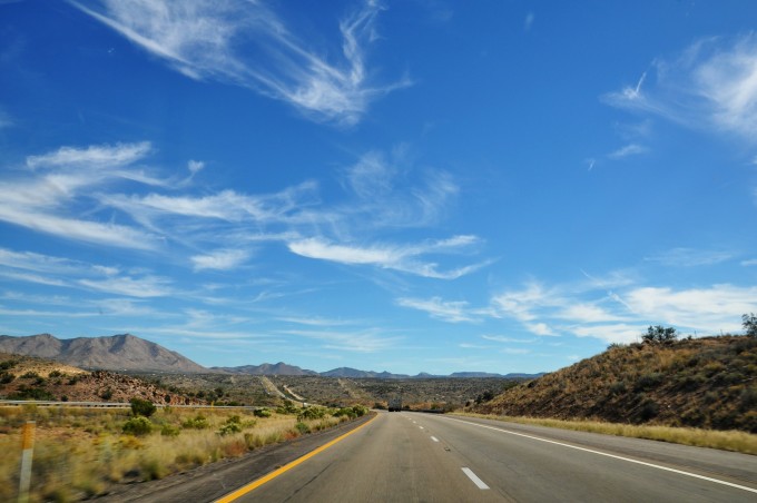
I have dreamed back to the magnificent western United States many times, and now I am running on the vast Colorado plateau, and I can’t help feeling a little excited. Starting from Las Vegas , we drove more than 400 kilometers all the way, and finally arrived at the gateway to the Grand Canyon National Park at three o’clock in the afternoon: the small town of Tusayan.
There are three must-dos for a scenic tour of the Grand Canyon National Park: watch the sunrise, watch the sunset, and watch the starry night. The sunset time in Arizona in March is around 6 o’clock. You can’t miss any of the stunning views of the Grand Canyon. Regardless of the fatigue of the long-distance trek, you put down your luggage and go out immediately.
Grand Canyon
It is about a 7-8 minute drive from Tusayan to Grand Canyon National Park. The Grand Canyon is divided into two parts, the South Rim and the North Rim. The South Rim, the most beautiful southern rim, is well developed and has been included in the US National Park, which is the part we will visit.
The Great Shaangu National Park, which does not charge tickets for tourists (only for vehicles), is quite well equipped. There are four free bus lines covering scenic spots in red, blue, orange and purple. Most of the red line scenic spots we went to at the first stop cannot drive by ourselves. After parking the car at the visitor center, we took the blue line shuttle bus around the service area and arrived at the starting point of the red line in a few minutes.
The red line Hermits Rest is the essence of the Grand Canyon, and it is also the westernmost point that can be reached in the park. There are nine stops on the road, and tourists can get on and off at will.
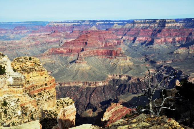
Walking into the first viewing platform and leaning on the railing, the magnificence of the Grand Canyon is quietly laid out in front of you. Although you have read many travel books, photos, and other people’s descriptions, the shock you see with your own eyes is not small. The information that the plane can convey, the magnificence and desolation in front of the eyes, hit the bottom of my heart at once.
The canyon drawn into the park is about 6 kilometers at its narrowest point and 29 kilometers at its widest point. Staring at the infinite ups and downs extending all the way to the horizon, I realized that the term “supernatural workmanship” is just an excuse used to barely describe the indescribable natural wonders.
There is a hiking trail with a total length of 19 kilometers along the edge for tourists to stroll along the edge. If you are tired from walking, you can find the nearest station and take a bus to the next scenic spot. The first few viewing platforms are adjacent to each other, and it takes about 40 minutes to walk, which is most suitable for strolling.
Even in well-developed tourist spots, the ecology here is very well protected. Railings are rarely seen on the edge of the cliff, which also provides opportunities for those tourists with adventurous blood. Sitting on the cliff in a daze becomes a scene of the Grand Canyon.
The sun was getting lower, and when we saw the obvious yin and yang side of the slanting light in the canyon, we walked a section of the edge trail and realized that it was time to watch the sunset, so we took a bus to the planned sunset viewing platform: Majave Point.
Watching the sunset in the Grand Canyon is different, not only to watch the golden sun gradually sinking on the top of the edge, but also to appreciate the magnificence of the sunset covering the canyon.
When the canyon is bathed in the afterglow of the setting sun, according to the inclination angle of the sun’s rays, the color of the rocks is reddish-brown, dark green, taupe, and the top layer is bright red according to different altitudes!
Until the end, the radiant sun was “swallowed” by the canyon, and in an instant, the canyon turned into a single silent green. Such a silent and ancient posture is so vigorous and magnificent that it leaves only silence and panting.
After sunset, the temperature of the Grand Canyon dropped rapidly, and the temperature at this time dropped by at least 10 degrees compared with the afternoon. The considerate and thoughtful free bus was waiting at the station, and the tourists on the edge were evacuated in an orderly and fast manner.
When we returned to the visitor center, it was already dark. Perhaps the silent Grand Canyon deliberately protected the dark sky to reduce light pollution, and there were no street lights. After finding the car in the pitch-black parking lot, we quickly hid in the car due to the unobstructed cold wind. However, in the Grand Canyon, one of the best stargazing places in the Western Hemisphere, this place that rejects light pollution is not the best place for us to stargazing? In this way, open the skylight and look up at the Milky Way full of stars, or stretch out your head to find the Big Dipper , and this becomes our romantic and unique stargazing station. When shooting stars streak across the sky, I pray that the world will be more beautiful.
In order to watch the most beautiful thing in the Grand Canyon: the sunrise, we got up early the next day, and the sky was still out of sight before we went out. I admire the staff of the Grand Canyon Park. They are already at work before dawn. This is in the United States The first group of staff who went to work I saw during the period! The seven-day valid ticket was posted on the window and passed smoothly, and immediately rushed to the best sunrise viewing point: Yavapai Point.
The viewing platform protruding from the edge is already full of masters who are ready to capture masterpieces, just waiting for the morning light.
The daring young man sits on the edge of the cliff, even if there is an abyss under his feet, he just concentrates and waits for the arrival of the sun to watch the unique wonder of the Grand Canyon sunrise.
It is similar to the setting sun at sunset, but the glow is more violent than the setting sun! The sun at the edge of the day tore apart the thick clouds and poured them on the rocks of the Grand Canyon. Colorful, vast and psychedelic like a fairyland.
At this time, the bright colors all over the world are extremely strong, the deep blue sky, the fiery red sunlight , the random clouds, the entanglement of light and shadow, are the most amazing, and people’s hearts are filled with irresistible shock to the magnificence of nature.
I couldn’t take enough pictures of the scene at this moment, and I found out when I got home that after taking pictures like this, I still felt that many details were missing. It is true that photographs will always pale in expressing the sensuality of nature.
After watching the sunrise, we returned to the hotel at 8 o’clock. After breakfast, we checked out and entered the Grand Canyon again. It was already a sunny morning. This time we parked at the start of the red line: the Bright Angel parking lot, and boarded the bus to continue the rest of yesterday’s trip to the west.
The formation of the Grand Canyon is due to the collision of two mountains due to the movement of the earth’s crust. How can it be so artistic?
According to Indian legend, the Grand Canyon was formed in a flood. At that time, God turned human beings into fish claws, so he survived the disaster. Therefore, the local Indians still do not eat fresh fish. In fact, the work of carving the Grand Canyon did not happen overnight, but has gone through hundreds of millions of years, and it has not stopped until now, forever. Human beings cannot perceive the progress of engraving every day, but the evolution of time shows an incredible spectacle.
The gorgeous sunshine sprinkled the bottom of the valley, which is another sight that people can’t stop. The stretches of scattered mountains top the blue sky, and the colorful Grand Canyon unabashedly shows the charm of nature to people.
When the wind of the Grand Canyon blows by me, I suddenly feel like flying. Subdued by such beautiful scenery, nothing can interfere with my long-awaited heart. I bravely walked to the edge of the cliff, raised my arms and shouted, even though there was an abyss behind it.
Hermits Rest, the terminal station of the red line, provides tourists with the only rest stop on the whole line, please add enough water.
The best way to get close to the canyon is to hike the canyon floor. There are two famous hiking trails in the Grand Canyon: Bright Angel Trail and South Kaibab Trail. We chose the most popular Bright Angel Trail Bright Angel Hiking Trail.
The heart-wrenching notices constantly remind hikers to pay attention to safety. The biggest enemy of hiking in the hot and arid desert is lack of water. There are no replenishment points on the way, so sun protection and sufficient water are very important.
Hiking the Grand Canyon is a thankless task. There are very few Chinese tourists. The Bright Angel Trail is 19 kilometers round trip and takes 8-12 hours.
The scorching sun along the way is hot and dry. Every hiker who plans to walk the whole journey must have a strong will and a strong physique. In consideration of time and physical strength, we only plan to walk 1/4 section. For the adventurous ghosts, it’s a bit ashamed, but it doesn’t matter, the focus is on participation.
Reminder from street signs: The road is narrow and narrow, be careful not to be kicked by mules. Haha, kind of interesting.
Circling down the inner side of the canyon, the canyon walls with clear and clear horizontal rock formations are displayed around you. Looking ahead, you can see the layer upon layer of red rock walls engraved with natural traces of hundreds of millions of years.
These geological deposits hundreds of millions of years ago have been eroded layer by layer by the Colorado River, and now they have left clearly visible lines, which seem to have made a section for the earth, and the state of rock formations in various historical periods can be seen at a glance, just like the growth rings of trees. , which provides a sufficient basis for geologists to understand the changes of the earth.
When you walk into the canyon, you will be amazed how this piece of land has been split in front of you by magic. This two-hour walk in the Grand Canyon is like walking through thousands of years.
In the visitor center, there is a free movie “The Grand Canyon” for tourists. The film took 10 years to shoot and shows the Grand Canyon of Colorado . Friends who are interested in geography are worth watching.
After hiking to the bottom of the valley, turn east and start the east route of the Grand Canyon. It is common for wild deer to walk swaggeringly on the road, and it is necessary for visitors to let their master know.
The free orange line bus can only reach Yaki Point on the east line, and you must drive by yourself for the remaining 30 kilometers. The terminal of the east line is the east gate of the Grand Canyon.
After experiencing the excitement of getting to know the Grand Canyon yesterday and the hardship of hiking the Grand Canyon today, the scattered scenic spots on the east line of the canyon can no longer stimulate our excitement. The canyons on the east line are a little gentler than those on the west line. Several observation decks are basically distributed along the highway. This road is just a short walk, and half an hour later you will reach the easternmost scenic spot of the Grand Canyon: Desert View.
Desert View means “desert landscape”, and the canyon becomes shallower and shallower here. The scenery here is different from that on the west line, with a wider angle and a wider field of vision. Looking hundreds of kilometers away at a glance, only the canyon in front of you extends westward, which shows the majestic momentum of the canyon.
In the viewing area stands a 70-foot watchtower built on top of Indian ruins, which is now protected as a historic site by the National Park. The first floor is used as a gift shop, and if you want to recall the real Indian culture, you can appreciate the murals of birds, animals or figures on the walls that depict Indian totems.
The watchtower can be said to be the commanding height of the Grand Canyon. Ascending the heights, you can have a panoramic view of the magnificence of the Grand Canyon.
The Colorado River, the creator of the Grand Canyon , lies here quietly. The river has been severely depleted in recent years due to drought and the construction of upstream dams.
Maybe subconsciously hope to find the footprints left by the previous life here, or maybe because of the short life and small size of human beings, they always have expressive reluctance to face the ancient and profound landscape. After lingering for two days, it was time to leave. Yiyi did not cross the Grand Canyon. At 2:00 pm, we walked out of the east gate and connected to the highway connecting Peggy, and we continued to advance to the Colorado Plateau.
horseshoe bay
The small town of Page on the Colorado Plateau is famous for two world -class attractions: Horseshoe Bend and Antelope Canyon . The 200-kilometer road from the Grand Canyon to Page is all standard asphalt roads, and there are very few vehicles on the road. On the road with a speed limit of 65 miles, I drove at a slightly higher speed and cruised freely while admiring the magnificence of the Colorado Plateau. Extremely.
Referring to other people’s experience, evening is the best time to appreciate Horseshoe Bay. It was too early to check in at the hotel at 3:30 p.m., so we seized the time to take a nap and set off for Horseshoe Bend (Horseshoe Bend) at close to 5 p.m.
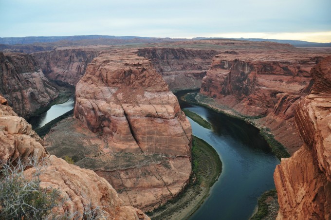
Horseshoe Bend is a section of Glen Canyon, named “Horseshoe Bend” because of the shape of a horseshoe surrounded by huge rocks. From the parking lot to the viewing area is a long red sandy road, with deserts and thorns on both sides. At the beginning, you have to climb the hillside. It doesn’t look high but it’s all soft sand. It’s a bit tiring to step on it and walk without exerting effort.
When I was almost at the top, I saw a small pavilion above, and I was very happy thinking that I had reached my destination, but when I went up, I found that it was just a resting place. We didn’t stop. It took about 20 minutes to walk to the viewing area in one go. Only then did we understand why everyone strongly recommends visiting Horseshoe Bay in the evening. In addition to the sunset light that makes the view better, there is also this rugged road. , Just imagine how hard it is to walk in such a hot and arid desert area without any shelter under the scorching sun. So a tall warning sign is erected at the entrance: bring enough water.
After a difficult trek, the magnificent Horseshoe Bend stands proudly in front of you. Such a scenic spot that does not charge tickets has shocked me even more than the Grand Canyon!
The magnificence of Horseshoe Bay is thrilling, but it is breath-taking. Under the thousand-foot cliff, the turquoise Colorado River made a perfect turn around the red sandstone, abruptly drawing a beautiful Ω, creating this natural and peerless scene.
The stalwart figure of Horseshoe Bay makes the Colorado River rushing around it as light as a stream. What is different from the Yarlung Zangbo Great Turn that I have seen before is that the flat plateau is more abrupt and magical than the Yarlung Zangbo Great Turn with mountains next to it.
If you want to take a picture of Horseshoe Bend, you have to approach the unprotected cliff. This test is not skill but courage. Not everyone has the courage to walk over the 1,000-foot cliff. When I tried to get close to the cliff, I was only 1 meter away and my legs were trembling. Stretching out my head to look at the bottom of the cliff more than 300 meters deep, I was really terrified. But after all, you can’t see the whole picture of Horseshoe Bay from this location. What to do?
Looking around, looking at the brave warriors facing the cliff, it immediately gave me courage again.
All you play is heartbeat! So I bent down and moved forward carefully, 0.5 meters, 0.4 meters, 0.3 meters… Finally, the panorama of Horseshoe Bay came into sight: it was like a horseshoe crushing a piece of crystal clear emerald.
Maybe it was the magical power given by nature. At this moment, I don’t know where the courage came from, but I stood up boldly. The moment I stood on the cliff, I suddenly felt majestic.
In the evening, the more emerald green water reflects the color of the surrounding rock walls, which is very charming in its depth.
The weather was getting darker, the clouds were very thick this night, and the gorgeous sunset came without an appointment. But the setting sun just tore a hole in the clouds, making this desolate land show a magnificent side.
In the distance, the small town of Peggy , is hidden in the vast desert, beautiful and peaceful.
lake powell
Today I made an appointment to visit another stunning Antelope Canyon in Peggy at 11:30. There was no special arrangement in the morning, so I slept late that day. I heard that Lake Powell next to the town has beautiful scenery, so this is a good place to relax this morning.
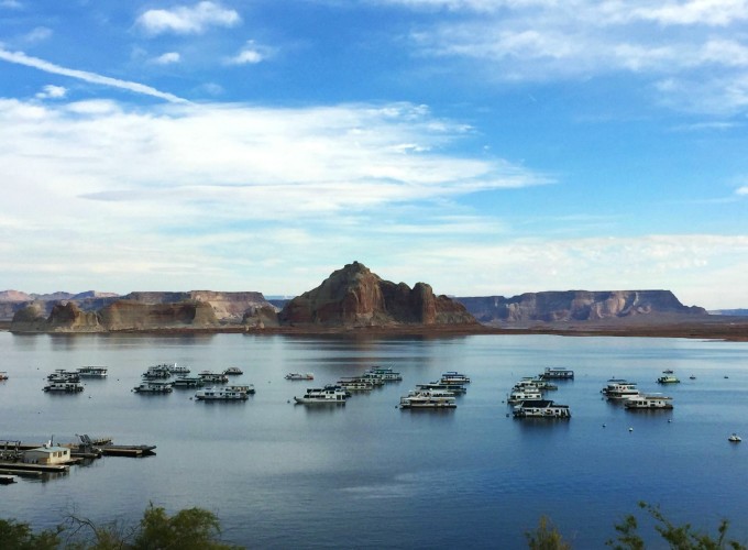
Formed by the construction of the Glenn Dam on the Colorado River, Lake Powell is the second largest man-made lake in the United States and is named after explorer General Powell. Today’s picturesque Lake Powell has built a sightseeing boulevard around the lake and built a resort, which has become the main resort for the middle class in the old America.
Walking along the main road and entering the sightseeing avenue, the first is the toll station. I don’t know if it’s too early or the tourist season has passed. The door of the toll booth is wide open and there is no one. We entered the resort for free. It costs $15.
A panoramic viewing platform is set up on the mountain, and you can have a panoramic view of the vast Lake Powell. The clear water and red rocks in the lake area illuminated by the morning sun are strange but harmonious. Because it was early in the morning, there was no one on the huge mountain, and the feeling of monopolizing this lake and mountain scenery was wonderful.
Gaoxia came out of Pinghu Lake , which was confirmed here. For the first time, I saw that the lake was not surrounded by green trees and green mountains but red rocks. The rocks by the lake continue the tone of the Grand Canyon, and the overall feeling is more brilliant due to the blue water of the lake. No wonder Lake Powell is known as the “Pearl of the Plateau”!
You can reach the lake by winding the road along the mountain. After driving in the desert for several days, I had enough to see the bleakness of the bare Grand Canyon, and suddenly there was a suffocatingly beautiful and calm lake in front of me. The kind of surprise can be imagined, like a long drought and sweet rain.
There are many boats parked on the lake. In order to facilitate the entry and exit of yachts, the main road around the lake is connected to the mouth of the lake. This is also the most water-friendly place in the lake area. Although it is only an artificial lake formed by the construction of a dam, because it is located in the Glen Canyon National Recreation Area with dense sandstone landforms, the beautiful Lake Powell is like a sapphire in the desert, giving people a noble and lazy beauty.
In such a peaceful and comfortable resort, I just want to stop. There was no one around, so I sat down on a bench and looked at the quiet lake, bringing out infinitely expressive peace. It’s still early, I’ve been running around for a few days, and it’s rare to find such a beautiful scenery. Although the autumn scenery is a bit bleak, it is still beautiful in my eyes. If time permits, I really hope that it will be like this, blowing by the lake Sitting in the wind for a day.
At 12:00 noon, when the sun shines vertically into the valley, it is the most beautiful moment in Antelope Canyon, the most psychedelic canyon in the world, and it is also the golden time for shooting. In order to get a seat at the best viewing time, it is necessary to book 2 months in advance. The price of the 2-hour photography tour from 11:30 to 13:30 is also 2-3 times more expensive than the other time groups, 100 dollars per person (plus 5 dollars for the reservation fee). After we made the payment successfully , there were only 4 seats left for the 12-person noon photography group, and it was hard to find a ticket. When you travel thousands of miles to go sightseeing, you must see the most beautiful scenery. This is our purpose.
Antelope Canyon belongs to the Navajo Indian Reserve and is divided into Upper Antelope Canyon (Upper Antelope) and Lower Antelope Canyon (Lower Antelope Canyon). The Upper Antelope Canyon is more famous and exciting, so it is our choice. According to the instructions of the tour group, gather at 11 o’clock. When visiting Antelope Canyon, you must follow the travel team of the local Indians. This is not only for the needs of natural and cultural protection, but also for the personal safety of tourists. Even if the sun is shining above the canyon, if a heavy rain falls suddenly, this narrow paradise may become a rushing hell in an instant. If you are not familiar with the surrounding environment, your life may be in danger at any time.
The tour guides are all Indian aborigines. Under the guidance of the bronze uncle, we sat in a special convertible four-wheel drive vehicle. Our photography team set off. Entering the Antelope Canyon area is a bumpy red gravel road. In the car that was blocked, let the wind blow wildly in the valley, and ran like a wild horse for 20 minutes before reaching the entrance of Antelope Canyon.
It was 11:30 at this time, and there were many tourists waiting at the entrance of the valley. The Indian guide uncle hurriedly greeted us and a group of 12 people to enter the valley. The sun is still hot outside, but once you enter the cave, you will feel cool and refreshing. Follow the guide into the Antelope Canyon, and you will be shocked by the soft colors and magical curves from the inner wall of the canyon! As if to another world.
Antelope Canyon does not have any artificial lighting! All the light you see comes from the “skylight” at the top of the canyon. It is repeatedly refracted into the bottom of the canyon through the rocks like silk flowing water. The dancing light and shadow here fully releases its charm. No wonder Antelope Canyon has become a paradise for photographers, even if it is dangerous. Can’t stop their footsteps.
In the dark valley, a ray of sunlight at noon shines in through the small holes above the canyon from the cracks in the rocks. This is the famous light of heaven in Antelope Canyon, as if a divine light flashed.
The red sandstone walls in the canyon were washed away by floods and storms like pieces of porcelain blanks ground by hand by masons.
The same rock will have different colors and textures under different lighting; the same location and different viewing angles can also give visitors different images and imagination. If you don’t visit the scene in person, it’s really hard to be sure that these magical and beautiful lights and shadows come from a single natural light source.
Antelope Canyon is a sandstone canyon formed by various erosions of soft sandstone. In the long river of development for millions of years, the canyon has experienced repeated erosion by mountain torrents, leaving “flowing” imprints on the rock surface, and solidifying these imprints into eternity in the most beautiful way. Driven by curiosity, I used my hands to touch the lines of different thicknesses wrapped around the red sandstone wall. Although the feel is not as good as silk, it is not as hard as rock.
The light and shadow in the valley change at any time with the position of the sun, and the effect of each shot is different. Although the tickets for the photography group are expensive, they get special care and stay for a relatively long time to take pictures. The staff also specially arranged some shooting spots to block other tourists and let us have a good time.
The Indian tour guide is obviously an old fritters. He is familiar with every location, angle and setting suitable for taking pictures in the canyon. He gives the group members special and unique photography guidance. Everyone can become a photographer here. Just take out your mobile phone and take a picture. , is an amazing photograph. Everyone is happy to take a satisfactory photo.
This world-famous slit-shaped canyon, because the slit is too narrow, can only accommodate one or two people in parallel or one person to pass through. If there are tourists coming from the opposite side, you need to wait patiently and avoid it. I don’t know if I am overwhelmed by the magical power of nature. The canyon is very quiet, only low sighs. The valley is not about 400 meters long. Walking and walking, suddenly the sun was dazzling, so it came to the end, and then returned to the original road, so you can take photos of the missed scenery at this time. But I suggest that the best thing to do at this moment is to turn off the camera and feel the magic and shock of being in this space-time tunnel. After all, for most people, photography is just a means to help us record our lives. It is not in vain to come to Antelope Canyon to enjoy the scenery.

monument valley
After finishing the journey in Antelope Canyon , Peggy had a buffet Chinese meal. It was more than two o’clock in the afternoon. He thought that he would rush to Monument Valley, 200 kilometers away, before sunset, because the afterglow of the setting sun is the most classic here. screen, and set off immediately.
It has been several days since I drove into the desert. Although I have seen the magnificence of the Grand Canyon and the thrill of Horseshoe Bend, the impression of the desolate, unrestrained and heroic western United States has never appeared in my mind. Until today, walk into the eternal symbol of the West: Monument Valley.
Only when you ride on the Colorado plateau can you appreciate the vastness of the western United States . Route 163 from Page to Monument Valley is an avenue in the vast desert. The openness and magnificence are definitely the best choice for shooting road blockbusters.
Back then, the tough and brave western cowboys rode their horses and whipped their whips to conquer the desert, but now we ride across the West on an iron horse.
Monument Valley is not a valley or valley in the true sense, but a giant buttes formed by sandstone in the Colorado Plateau. From Arizona to Utah , scarlet flat-topped hills and weird sandstone towers began to appear, and the long red sand submerged the area in a deserted desert. Seeing everything in front of me, the West became clear in my heart, yes, the West should be like this, unrestrained, free and unrestrained.
Monument Valley is the territory of the Navajo people and belongs to the Indian reserve. It costs 20 dollars per car to visit. It was only 4:30 pm when we arrived, and no one was collecting tickets, so we drove straight in. In order to keep the original appearance of Monument Valley as much as possible, after entering the park, there is a comprehensive service area. Pedestrians have a designated activity area, and a viewing corridor with an excellent view is set up around the service area.
Standing casually on the viewing gallery, the magnificence of the openness in front of us immediately stunned us. This Monument Valley with an area of 30,000 acres is the result of millions of years of continuous deposition of layers of sediment in the basin. The huge pressure under the surface lifted this area to form a plateau. The erosion by wind and rain has evolved into the scene we see today. These “monuments” formed by thousands of years of wind erosion, together with the desert and the blue sky, show the infinite power of nature amazingly here!
Time is eternal, and all things reincarnate. On this unseen red sandy land, three natural stone monuments with a height of 300 meters stand abruptly. The combination of the three standing “monuments” is like a totem of the west, which is awe-inspiring!
For the Navajo Indians, this magical and magnificent red Gobi is a sacred place bestowed by God. In history , white people from various countries in Europe drove Indians from their homes many times, forcing them to flee into such desolate and barren mountains and deserts.
Friends who love American westerns, I believe you are familiar with the scenes here. Yes, because the magnificent landscape here has long been an ideal location for film and television shooting. Several works of the famous director John Ford have been filmed here, including the Oscar-winning film “Flying across the Mountain” and “The Searcher”, ” Forrest Gump, Back to the Future, 2001: A Space Odyssey, and more. Early Hollywood filmmakers let the world know the mysterious place of Monument Valley by shooting movies.
Looking at this familiar scene, the classic images that appeared in Marlboro advertisements in the 1970s can’t help but emerge: rough, heroic, and heroic western cowboys riding horses and whipping. Western cowboys are actually the story of white Americans in the 19th century , and the cowboys that Americans are proud of were born here.
As the sun set, its fiery rays lit the valley like a burning brazier. The magnificent light and shadow slowly drift over the magnificent valley, and the desolate desert is intertwined with yin and yang, which brings out a picture scroll of the earth with great pride.
The most unique shape in the valley should be the two glove mountains that echo each other from a distance. They are like a pair of thumb gloves, with one branching on the right and the other on the left. It is said that one day in mid-April every year, the sun will cast the shadow of one glove onto another one after another, and the overlap is very good. This is really a masterpiece carefully designed by nature.
When the sunset shines on the “monument”, it emits a fascinating halo, just like the light of Buddha. I never thought that the desolate land can have such a gorgeous scene, which brings us an unprecedented shock!
At this time, the Monument Valley is completely silent, except for the whistling mountain wind. In this situation, the only thing I can do is to concentrate and enjoy the magnificence bestowed by the God of Nature.
Seeing such a sacred sunset, I really deserve this trip. The sky was getting dark, and although I was still intoxicated by the charming scene of Rizhao Field, I had to set off immediately to another attraction more than 10 kilometers away: Forrest Gump Point.
The fall of night adds to the mystery of this land. There are grotesque and lonely hills standing on the side of the road. We have to sigh that the land area is too large. We are speeding on this vast desert road, and we feel that the end of the world is in front of us, but it will never Can’t drive through either.
The first time I knew about Monument Valley was through the movie “Forrest Gump”. In the movie, Forrest Gump ran around the United States, and the place where Forrest Gump finally stopped was the landmark scenery in the western United States, which is now called: Forrest Gump Road .
Forrest Gump, who has been running across the United States for several years, must have felt something when he ran across this mysterious land. Is it the indomitable Indians? Is it the will to live of the pioneers of the West? Or is it the death of the Cowboys? In Forrest Gump’s simple mind, these genes that constitute the national spirit of America today were activated, so he stopped and decided to go home and start a new life!
The road passing by the valley is famous all over the world because Forrest Gump runs here. Many movie fans have traveled thousands of miles just to see this mysterious movie scene.
The highway remains in its original state, and running for a while after imitating Forrest Gump seems to have become a designated action.
The majestic Monument Valley and the quiet sunset complement each other. It is difficult to see this quiet but heart-wrenching shocking beauty. Photos can record the travel process, but it is difficult to express everyone seeing these scenery The perception of time. The sky suddenly darkened, and at that moment, it seemed that the earth was no longer turning, and there was a feeling of the end of the world. But there is no fear, because the individual consciousness also disappears at that moment…
The straight road under the colorful clouds leads to the distance, and there are still 200 mountain roads to catch up. At 6:30 in the evening in late autumn, the day after tomorrow was exhausted. After leaving Monument Valley, our car drove into the dark and vast plateau. There are almost no cars on the road under the night. It is the first time to try to drive on the deserted road in the dark. Even if our car is alone, it can give birth to a sense of satisfaction. On the road, I occasionally meet a car that is also a passer-by, but it quickly disappears into the night… The coexistence of novelty and excitement is the boundless fun of driving.
After driving 240 kilometers in the dark for 2 hours, we arrived at our destination at 8:40 p.m.: the small town of Moab (Moab) outside Arch Park. Under the guidance of the navigation, we quickly found a booked motel to check in. The wonderful day ended. Wash and sleep.

arches national park
There is a well-known natural treasure in eastern Utah . On its 309 square kilometers of land, there are more than 2,000 natural rock arches of different sizes and shapes scattered on the record. It has become the largest natural sand arch in the world. The concentration of rock arches, this amazing and magical place, is our next stop: Arches National Park (Arches National Park).
At 7 o’clock in the morning, I woke up naturally after a sleep, and what greeted us every day in the dry desert area was a sunny day without any suspense. deep inland usa utah Arches National Park may only come once in a lifetime. In order to gain more time to visit the essence of the park as much as possible, we did not stop in Moab and set off immediately after breakfast. At 8:30 in the morning, the staff at the toll booth hadn’t gone to work yet, and the green light told us that there was no one to charge but it was unimpeded.
Arch Park, covering an area of 309.7 square kilometers, connects the magnificent scenery and the main arches through a 78-kilometer round-trip landscape road. The park is divided into four major scenic spots. The first stop goes straight to the Devil’s Garden at the northernmost end.
The 39-kilometer drive from the gate to the Devil’s Garden is definitely an eye-catching place. The blue sky is paired with the huge rock scene piled up by red sand, and the various forms make it too late for you to digest all the way.
There are reddish-brown rocks and yellow land in front of my eyes, and the sky reveals the unique desert blue under the morning glow, which makes the world look high and wide. If it weren’t for the little green of some drought-tolerant plants on the ground, I would really doubt it. Are you in a place where life exists?
The Devil’s Garden is famous for being full of strange rocks, and what we are attracted to is the longest natural arch in the world: Landscape Arch (Landscape Arch).
After a good night’s rest, we can walk like the wind even under the scorching sun. After 20 minutes, the longest natural arch in the world stands proudly in front of us.
According to the position of the sun’s rays, the morning is the best viewing time. Spanning 90 meters in the air, the scenic arch connecting the rocks on both sides hangs high in the air, as if a natural colored chain was born out of the sky. It is the longest natural sandstone arch in the world recognized by the International Association of Natural Arches and Bridges.
This seemingly long and slender arch gradually collapsed due to continuous weathering, and has become extremely thin and fragile. I heard that a few stones just collapsed a while ago, and it seems that it may collapse at any time. If you want to see its style, please go there as soon as possible, because maybe one day not far away, there will be a news: the longest arch in the world, Landscape Arch, is dead.
The Scenic Arch is only halfway to the Devil’s Garden, and there are still 2 kilometers left to reach the Double O Arch (Double O Arch). But don’t underestimate the distance of 2 kilometers, because there are almost no roads, there are strange rocks everywhere, and a so-called road just walks through the strange rocks.
However, there are many drought-tolerant plants such as cacti in the open area of the mountain, which may be the reason why it is called the Devil’s Garden. There is no doubt that this is a place of original ecology.
There are also some less popular attractions in Devil’s Garden, such as Partition Arch, Navajo Arch, Pine Tree Arch & Tunnel Arch, etc., you can drop by here. Today’s itinerary is rich and time is not enough. We didn’t finish the journey, so we wandered here for a while and then went back to the parking lot.
On the way back from the Devil’s Garden, the change of angle, as if new landscapes were born on both sides of the road, is still dizzying.
On the way to the next stop, there is a scenic spot: Fiery Furnace (Fiery Furnace). The furnace does not refer to a hot furnace, but at dusk next night, the stones here look red like fire, hence the name.
Some of the stones on the surface of the furnace look like fish fins, and some look like spires, all of which are the result of surface movement hundreds of millions of years ago. Coupled with the long-term erosion of rain, snow, and ice, the cracks in the rocks continued to deepen and widen, and finally formed these towering, fish-fin-shaped surfaces.
Among the many arches, large and small, the most famous is the exquisite arch printed on the Utah license plate. It is not only the symbol of Utah, but also the treasure of the town and garden. It was specially arranged for the 2002 Winter Olympic Games torch relay. Pass under the Delicate Arch.
It is not easy to get close to the exquisite arch, and the journey is a small challenge. There are 5 kilometers of mountain roads from the parking lot to the exquisite arch. Attention, it is a mountain road! Moreover, it is a mountain road that keeps going uphill, and the strength is doubled, which is equivalent to a 10-kilometer flat road. Anxious to see the true face of this arch, we parked the car and ran to the mountain.
This road is not a regular step. First, there is a narrow winding path, then polished ridges and rugged rock crevices, and finally a steep cliff ridge.
Sunshine on the plateau not only brings us blue sky, but also intense ultraviolet rays. The temperature of the park suddenly rose at noon, and only then did I understand why the park advises tourists to bring enough water when walking in such a place without any supplies. (The official recommendation is to bring at least 2 liters of water per person for this hiking trail).
Sometimes I really envy Westerners, they seem to be able to shield ultraviolet rays, and the white-skinned people all over the mountain are full of short clothes and shorts. In the face of such powerful ultraviolet rays, we don’t want to be burned, so we have to wrap ourselves tightly.
Walking through wave after wave, turning around mountain after mountain, every time I climbed to the top of the slope, I thought I wanted to rest, but I saw the tourists in front of me walking on the back of the cliff without looking back, and hurriedly followed . At this time, I can’t help but wonder why I am willing to trek down this bald mountain in the scorching 40-degree sun, and walk several kilometers to see the stones. How exquisite is this exquisite arch?
Turning around the end of the cliff, looking back suddenly, it suddenly became clear : a slope suddenly appeared on the top of the slope full of strange rocks, as if it was a natural stage specially provided for exquisite arches, and a huge inverted U-shaped arch was safely on it. This world-famous exquisite arch is suddenly displayed in front of you. At this time, there is no cheering, no admiration, and some actually have an inexplicable sense of awe.
If you don’t go to the front of the arch, you can’t appreciate its beauty and shock, and people are as small as ants under it. The front of the arch is a deep pit, and the rear is a cliff, which is very dangerous. While many natural arches have collapsed due to excessive wind erosion, delicate arches are known to have withstood wind erosion for a long time without collapsing. Looking at the exquisite arch standing proudly on the edge of the cliff, it seems that this should not be the scenery that human society should have.
It was 4:30 p.m. when we walked out of the court tower scenic spot. The 8-hour compact itinerary was close to a 20-kilometer hike, and it was an exhausting day. but! After leaving Arch Park, there is still a 430-kilometer expedition waiting for us!
Traveling in such a vast and sparsely populated area not only marveled at the vastness of the western United States, but also challenged our strength. Fortunately, the trip to Western Australia has developed a solid skill. We started the chariot like an iron man and drove straight on the Colorado plateau. on the highway…
The weather was unpredictable, and when we left Arch Park the gorgeous blue sky turned cloudy and then poured rain. Although it was exposed to the sun for a day, I am also grateful for the gift of God, which gave us a sunny trip to the arch.

bryce national park
The uncanny workmanship of nature has carved out a variety of amazing topography and landforms in the Colorado Plateau, creating a world-famous American National Park. Among them, Bryce Canyon National Park (Bryce Canyon National Park), which is located in the remote southwest of Utah and known as the palace of stone figurines, is locked as our next stop.
After 4 hours of racing all the way across the mountains after leaving Arches Park, it was already past 8 pm when we arrived at Bryce Canyon National Park Resort. It was pitch black in the wilderness. After checking in at the front desk, according to the map guidance provided by the waiter, I quickly found a room to check in. 20 kilometers of hiking, 500 kilometers of driving, the iron-like strength of Arch Park is the end of the day.
Sufficient sleep is the last word to ensure physical strength. A night of sweet sleep seems to be full of vitality. After breakfast, I packed my luggage and arrived at the toll booth at the gate of Bryce Park at 8 o’clock. The toll collectors here are much more diligent than those in Arch Park in Utah. “Early birds” can’t enjoy free tickets, and they buy tickets for $30 per car to enter the park.
There is a main road in the park, and there are multiple viewing platforms along the way from the entrance to the end point. Among them, the four most famous points are set around the semicircular main scenic spot. Today’s itinerary will focus on these four best viewing platforms tower.
Standing high and looking around at 270 degrees, the magnificence of nature is immediately blown in your face. What greeted us in Bryce Valley was a super-powerful and luxurious “guard of honor” dressed in gorgeous costumes. The 5-kilometer-wide natural guard of honor stretched for more than 10 kilometers. This battle was more grand than I imagined. I am really “flattered” to receive such a high standard of “courtesy”.
The scientific name of these “guards of honor” is Yanzhu. The geological changes of the Colorado Plateau can be described as vicissitudes of life. Nature has cut the sedimentary rocks of the river bed for hundreds of millions of years through wind and water power. After countless years of meticulous carving, the sedimentary rocks have become mainly red, mixed with orange and white. or rock pillars of other colors. Gradually, the stunning landform features seen today were formed.
The stone pillars easy to make people imagine. They are neat and orderly, like the Terracotta Warriors and Horses of Qin Shihuang, the palace in fairy tales, or the parade ground of the gods, but the park management department has an official name for it: Bryce Amphitheater (Bryce Amphitheater) Amphitheater).
The mountain ridges on both sides of the valley are in the shape of a semicircle, and the stone pillars drop down to the center of the circle along the ridges in an orderly manner. It really is a spectacular natural amphitheater.
Convenient roads connect the four viewpoints around the “Bryce Amphitheatre”, each 2-3 kilometers apart. Wild donkeys roam the roads, playing hide-and-seek with visiting cars.
It takes only a few minutes to go from Bryce Point to Inspiration Point, and the change of location allows visitors to appreciate this huge amphitheater from different angles.
Under the sky-blue curtain, the audience seats are densely packed. They seem to be concentrating on listening to a magnificent symphony with ups and downs, and it seems that countless football fans are watching a thrilling game, and they keep cheering. Come.
Los Angeles
Los Angeles , the City of Angels , has become one of the most popular tourist cities on the west coast of the United States because of its status as the cultural and entertainment center of the United States . Disney, Universal Studios and other parks have been played elsewhere. For those who only have one day in Los Angeles We who are wandering around are more attracted to the Hollywood area where the top pop culture gathers.
Sunshine filled the earth, and more than 2,000 star-shaped medals inlaid with the names of celebrities honored by the Hollywood Chamber of Commerce were spread along the street. There were few tourists in the early morning, which allowed me to leisurely count the stars.
Stars represent eternal memorials to those who have distinguished themselves in the entertainment industry, bearing the names of actors, musicians, directors, producers, musical ensemble bands, theater groups, fictional characters and others.
In addition to the stars on the Avenue of Fame, there are countless Hollywood shops that attract people’s attention, clothes, shoes and pants, postcards, movie posters, and even simulated Oscar statuettes . Everything about Hollywood can be found here.
The Chinese Theater is named after the appearance of Chinese-style buildings, and the interior of the theater is also designed with the concept of Chinese art. However, as Chinese , when we look at its appearance, we always feel that it is a bit nondescript. We can only say that this is China wind!
When the Oscars are presented in March every year, the Dolby Theater, which symbolizes the glory of the film and television industry, gathers stars and becomes the focus of the world. The Dolby Theater, which has the largest stage in the United States, undertakes the annual Oscar awards.
The Dolby Theater, formerly known as the Kodak Theater, was unable to pay high naming fees due to the gradual decline of Kodak in 2012. The famous audio production company Dolby Laboratories (Dolby Laboratories) obtained the naming rights of the theater for the next 20 years. It’s a pity that the old Kodak is over like this. After Dolby took over, this place is still the focus of the Oscars, and it is still as brilliant as ever!
The three-story corridor next to the Dolby Theater is a viewing platform for tourists to look at the Los Angeles business card “Hollywood” sign. These huge letters standing 14 meters high on the top of the mountain are definitely the most frequently photographed landscape in the western United States.
At noon, I had a dinner with friends. The garden-style shopping mall in the city not only meets our requirements for a happy gathering, but also allows us to shop happily. It can be said to kill two birds with one stone.
Walking on the streets of Beverly Hills, under the shade of two rows of palm trees, you can see luxury villas and courtyards one after another everywhere. Expensive sports cars drove past one after another, maybe it was a certain Hollywood star walking towards him.
The original plan was to go to the most beautiful beach in Los Angeles: Santa Monica Beach (Santa Monica Beach), enjoy the beautiful sunset in the Pacific Ocean, and watch the busy road in Los Angeles, but it was shaken at this time. The thought of giving up on the plan also surprised me. Yesterday, I galloped for thousands of miles with pride, and the day before yesterday, I walked 20 kilometers hard. Why do I want to give up the beautiful scenery that is close at hand today? It’s really not our character. But as soon as my spirit relaxes, I immediately become full of inertia, thinking that I will go home tonight, and I have no intention of fighting for the rest of the itinerary. Well, Los Angeles We will come again, and doing it rashly is also an experience of the journey.
There are more than 6 hours before the boarding time, and I found a well-known coffee shop Urth Caffé nearby to pass the time. It is said that the coffee of Urth Caffé comes from the coffee tree species grown at the highest altitude, and is carefully crafted in strict accordance with European coffee production standards. . In order to ensure the pure taste of coffee, Urth Caffé strictly controls its procurement, roasting and distribution. In 1998, it was awarded ” Los Angeles Coffee” by Los Angeles Magazine. No. 1 Café Restaurant” and is also the most popular dining place for celebrities in Beverly Hills. If you don’t care about the cost, but just want to see the real face of celebrities and experience their daily dining experience, you can’t go wrong with Urth Caffé.
Arrive at Los Angeles International Airport early with the aroma of coffee. After returning the car that accompanied us for more than 10 days, there was a small episode. When we left the parking lot and got on the bus to the terminal building, we found that the rucksack with the camera was left on the car. This is the whole of our trip to the west of the United States Record, crazy! So he hurriedly told the driver to stop, and ran to the parking lot at the speed of a flying man… God bless, the rucksack was finally returned to Zhao, and I really broke out in a cold sweat.
In addition, there was a small episode on the day of arriving in the United States : every immigrant must pass fingerprint verification to enter the customs. When it was my turn, 10 fingers repeatedly verified and failed to pass. The big brother of the customs officer went to the next door to ask , the answer is that everything is normal in the system. So my elder brother brought me a bottle of alcohol cleaning solution and asked me to wipe my hands and try again. As a result, I passed the fingerprint as soon as I pressed it. It was only then that I remembered that I had applied body lotion on my hands before getting off the plane… Delaying time is a small matter, but causing misunderstandings is a serious problem. This lesson must be learned!
As the plane took off, on the morning of the third day (“back in time” at the time of departure) we were greeted by the morning glow of Guangzhou. So far, the first season of Traveling to the United States has come to a successful conclusion! See you in the second season.