
The strategy of Las Vegas is in the previous strategy. If you want to see it, you can go and see it.
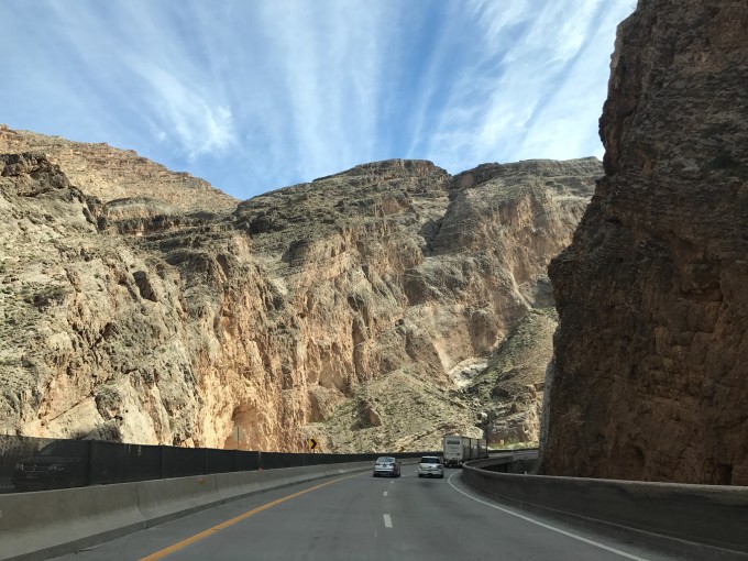
Peggy is a small town, and the public transportation is not very developed. When the car enters the territory of Peggy, the vast expanse of red sand on both sides of the road Overgrown . April, September and October are the best seasons for tourism, the temperature is relatively low, there is a little rain, and it is relatively humid; the dining facilities in the scenic area are not complete, especially Horseshoe Bend and Antelope Canyon, it is recommended to bring some food, be prepared .
I personally have a plot for Antelope Canyon,. I saw a photo of Antelope Canyon by chance a few years ago, and I fell in love with it at a glance. I decided to go here once. It’s really worth the trip! And I also want to go there for the second time to appreciate the magic of nature and leave us with such a beautiful scenery…
Antelope Canyon,, which is called one of the top twenty weirdest tourist destinations in the world, can be seen from the photos alone so gorgeous. Antelope Canyon is located in the northern part of Arizona, near Page , from Las Vegas to Page This section of the road, a total of four and a half hours, will enter Arizona from Nevada, and then enter and exit from Utah , all the way is the United States Typical desert and canyon landscape of the west.
Our itinerary is to fly to Las Vegas and then rent a car to Peggy , intending to see the three scenic spots of Antelope Canyon,, Horseshoe Bend and Lake Powell.
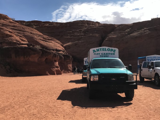
It is recommended to book tickets for Antelope Canyon, in advance, otherwise there may be no tickets, you can choose the time to follow the group online. (One point worth noting: don’t miss the time, they won’t wait for you even for a minute, they will start the bus directly, so don’t be late!!! They have a very good sense of time) Since we don’t know when we will arrive , They have a time limit to choose, so they didn’t book online in advance, we bought it on the spot (a lot of people said that tickets were difficult to buy, but I went there and thought it was okay, there was no need to grab tickets at all, There are quite a lot of people who buy it in the store, just need to wait time) We waited at the door for more than half an hour when they didn’t open the door, so when you go, check the business hours in advance, go in and buy tickets and wait for another half an hour, on-site There are enough people in the group to start. Antelope Canyon is divided into Upper Antelope Canyon and Lower Antelope Canyon, each of which has several businesses in operation, you can choose by yourself (I will post a picture of where I bought the ticket from, this one is reliable and good after I searched).
The light of angels can only be seen in the time period around noon in the Upper Antelope Canyon. After all, the main reason for everyone to go to Antelope Canyon, is the dreamy beam of light that shoots into the bottom of the valley from top to bottom—the light of angels, so we choose Depart for Antelope Canyon in the morning. When we went to buy tickets, the staff asked us where we were from, and when we learned that we were Chinese , we made arrangements, and then we realized that they would put Asian People are grouped together, so most of our group are Chinese a lot of Chinese tourists. We chose to go to the Upper Antelope Canyon, because the light of the angel can only be seen in the Upper Antelope Canyon.
Most photography groups will go to the Lower Antelope Canyon, and the visit time of the Lower Antelope Canyon will be canceled at any time according to the weather. There is another important reason It is because of the magical structure of Antelope Canyon that accidents are prone to occur. Since the Lower Antelope Canyon extends northward and connects to Lake Powell, when it encounters flash flooding, the flood can directly rush into the canyon. The flash flood in 1997 A total of 11 tourists died in the accident. Since then, the government has established a relatively complete detection and early warning system, so now you don’t have to worry about flash floods when you go to the Lower Antelope Canyon.
PS: Antelope Canyon will be closed when it rains, so be sure to check the weather forecast before you go!
Go to Peggy is a masterpiece of nature along the way – all kinds of big rocks.
Upper Antelope Canyon Upper Antelope Canyon
Tes’bighanilini
means “the place where runs through rocks”
Alias: “crack” (the Crack)
Navajo paraphrase: “Where the water washes the rocks”
Lower Antelope Canyon Lower Antelope Canyon
Hasdestwazi
means “Spiral rock arches”
alias: “corkscrew” (the Corkscrew)
Navajo paraphrase: “arched spiral rock”
Antelope Canyon is the jurisdiction of the Navajo Indians, so they are all Indians In business, tourists are not allowed to enter the Upper Antelope Canyon alone
, which is more suitable for the elderly and children. The road is very flat. The Upper Antelope Canyon is more famous than the Lower Antelope Canyon. The Antelope Canyon that most people refer to refers to the Upper Antelope Canyon. Because it is more popular here, because there are beams of light here, and because the tour group here in the peak season needs to be booked long in advance. There is a long wash connecting the Upper Antelope Canyon and the main road. As shown in the picture, ordinary private cars cannot drive on such sandy ground, so the group of the Upper Antelope Canyon must be in Page Concentrate in the town, and then a large modified pickup will transport you to the entrance of the canyon. It takes about 20 minutes one way from the town to the entrance, and the so-called duration of various tour groups minus 40 minutes, the rest is your real time to play.
Due to the structure of the Upper Antelope Canyon, which is narrow at the top and wide at the bottom, a beam of light will be formed when sunlight passes through the top slit at a certain position around noon. The canyon is in a red rock cave. When the sun shines in from the top, the cave turns red. . It is also necessary to add a condition to this “around noon” – from April to September, the best season is between the end of spring and the beginning of autumn, and only when the sun is high enough will there be a beam of light directly hitting the ground, so it is really But it’s all about luck!
It is worth noting that:
Ordinary groups in Antelope Canyon can only use mobile phones to take pictures. If you want to bring a camera SLR, photographers who are going to carry a tripod for long exposure must participate in a photography group and buy a ticket for the photography group. The stay time will be longer than ordinary tickets. In addition, it is allowed to carry a tripod, of course, remember to prepare more cash, the tour guide will tell you how to take good pictures, and naturally you need to tip.
The tour group is divided into a regular group and a photography group. If the photo requirements are not particularly high, it is recommended to register for the regular group. The regular group stays for a short period of time, about 1 hour, and the photography group is twice as long, about 2 hours.
Upper Antelope Canyon: Regular Tour – Adults, $47/person; Children (2-12 years old), $39/person. Tickets are a bit more expensive during peak hours (11:30-13:00), but because the light is the best, tickets are also the hardest to buy. The photography group is about 80 US dollars per person, and each group has about 12 people.
Lower Antelope Canyon: Regular Group – Adults, USD 27/person; Children (2-12 years old), USD 19/person. The photography group is about US$50/
The ground of Antelope Canyon is mainly sandy, so pay attention to protecting the camera to avoid sand entering, and never change the lens inside! ! !
Peggy’s local time does not adopt daylight saving time like most parts of Arizona. If you come from other states, you must find out the time of the visiting group.
Various visiting groups have different age restrictions for children. Parents with children must be careful You have to see it clearly before booking tickets.
Don’t turn on the flash when taking pictures. The tour guide will specifically say before entering that the colors produced by the flash have no sense of hierarchy, and it will affect other people’s photos. If you don’t turn on, everyone is good.
Ordinary groups also need to tip the tour guide. As for how much it depends on personal preference, there was a middle-aged Chinese couple in our group who didn’t give any money. They even asked the tour guide to help take pictures. I personally think it’s not good to not tip There are actually a lot of sand floating in the air in the good.
Antelope Canyon, but because it is dark in the canyon, you can’t see it. The tour guides often go in and out, so they will wear masks. We feel good about the whole journey, as long as we don’t stay in it all the time. You don’t need to wear a mask. When you came out, you found that your clothes and shoes were sandy, and you didn’t feel it at all
We picked this place online, navigated to this address, and bought tickets directly. There will also be some souvenirs to buy.

When you arrive at the gate, the tour guide will tell you to change the camera mode to Ming Huang, which is very good-looking. About a dozen people are accompanied by a tour guide. Of course, the tour guide is American or Indian, and they are all very nice!
How to take pictures really looks good. Every time you walk a certain distance, the tour guide will explain to you which angle and position it will look like. If you need it, you can also ask the tour guide to help you take pictures. They are really nice!
While walking, a beam of light suddenly appeared. I was very excited. I didn’t realize it at first. Before I came, I read the weather forecast and said that it might rain. I was especially afraid that the Antelope Canyon would be closed. Without sunshine, I would not be able to see the angel. Light, very lucky! very lucky! Seeing the legendary light of an angel, a beam of light shines through the gap to the bottom of the valley, and the Tyndall phenomenon occurs. After hundreds of thousands of years of polishing, the lines and color blocks are as smooth as porcelain, even if there is sunlight, it is not every time. I can see it, and I feel really lucky and complete! ! !
The Lower Antelope Canyon is close to the main road, so you can drive there without having to gather and take a big pickup truck . However, unlike the flat Upper Antelope Canyon, which is suitable for the elderly and children, the Lower Antelope Canyon needs to climb a few iron ladders to go deep into the cracks in the rocks. The Lower Antelope Canyon is about 500 meters, hidden in the cracks of the ground, mysterious and dangerous, the entrance is only one person wide, and it is only open for almost three months in a year! ! In the underground Lower Antelope Canyon, the terrain is complex and there is no light. It needs to go down the ladder, so there are many iron ladders, safety nets and ropes inside. It is difficult to enter. Naturally, there are few tourists. Most of them are photographers, including the elderly and children. It should be noted that there is no famous , which depends on the structure of the canyon-the relatively wide top opening, such a structure is a benefit for those who are not good at photography-the light is sufficient, and it becomes easier to take pictures. The Lower Antelope Canyon does not need to wait for the light beam, so the visiting time is relatively free, all year round, but in July and August 9:30-10:30 is the best time to shoot in the Lower Antelope Canyon; other times, early morning and evening It is the best time for photography.

I bought this dream catcher made by Indians while waiting in the store, I hope it can give me good luck~
Horseshoe Bend Horseshoe Bend
is very close to Antelope Canyon, only 16 minutes by car. Drive northeast from Page to Highway 98, turn right at Indian Rte 222 to the Upper Antelope Canyon parking lot, and turn left to the Lower Antelope Canyon. Colorado River in Arizona.
An ordinary , because of the rare 270-degree U-shaped bend and more than 300-degree vertical drop, becomes not ordinary at all. With the help of sunlight, the soil contains a lot of iron and manganese, and the unique landform The breathtaking scenery has attracted a large number of photographers and tourists, and has become an unmissable scenery in people’s eyes.
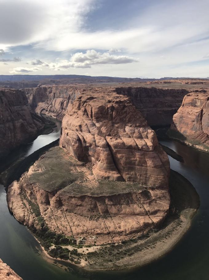
Although there is only one viewing point in Horseshoe Bay, it is difficult to find the second one in the world in terms of shocking level. Those with children on the cliff without any protective measures need to pay attention to safety, and those who are afraid of heights may not be able to stand it. I want to pat the horseshoes The overall picture of the bay is very difficult. If you are not brave enough and your heart is not strong enough, it is really not recommended to take risks. After all, there are no gentle protective measures. There is a cliff below . After 10 minutes, you will find a large parking lot on the right. After parking the car, walk over a small hill about 300 to 400 meters high to see the true appearance of Horseshoe Bay. It takes about half an hour from the parking lot to the destination. We arrived at Horseshoe Bay after seeing Antelope Canyon, so it was afternoon.
Attention! This is a desert area. It takes a long way to go from the parking lot to Horseshoe Bay. There are more than one road, and the temperature is relatively high. Therefore, it is recommended that one person bring a bottle of water. Be careful when taking pictures, stay away from dangerous areas such as cliffs, and open to the public.
The most conscientious thing about opening Horseshoe Bay all day is that there are no tickets. No matter when you want to stay for as long as you want, the scenery of Horseshoe Bay is different at different times of the day. There is a bay of clear water at noon. In the evening, the river water will be reflected The colors of the surrounding rock walls are deep and charming. If you book half a year in advance, you can take a sightseeing helicopter to overlook the entire Horseshoe Bay. The shock and surprise will make you unforgettable forever. Address: US-89 Page, AZ 86040. Fine red sand and desert plants
The next day, I plan to drive to Bad Water. Badwater is the lowest national park in North America. The name comes from a small pool formed by an underground spring here. Due to the accumulation of salt in the basin, the water in this pool cannot be used for human consumption. , the honeycomb-shaped salt crystals in the basin are gradually formed from the salt crust on the surface of the basin due to the annual rainwater evaporation cycle and repeated freezing and thawing.
Badwater is the Death Valley of the United States. It used to be a lake, but now it is almost dry. Death Valley It has a total area of 3,000 square miles, of which 550 square miles are below sea level. It is located on the border of California and Nevada, just a distance from Las Vegas About 224 kilometers. Due to the drought and raging fire-like climate here, many gold prospectors who took Death Valley as a shortcut to mine in California often died in the ruthless desert. And got its name. The annual rainfall in Death Valley is only 1.9 inches. This rare amount of water mainly comes from the Gulf of Mexico in the south. This place used to be an inland lake. Since the Ice Age in the Sierra Nevada disappeared, there has been no spring melted snow into the lake. Coupled with the hot climate, 150 inches of lake water evaporates in one year. Another main reason why Death Valley’s climate is so dry is that the three mountains of Sierra Nevada, Panamimt, and Agus form a rain barrier, and the sea breeze from the Pacific Ocean There is almost no way for the carried moisture to enter the valley, making the chance of rain here even more negligible.
The natural landscape here is good, and you can visit all the points while driving, but it is not recommended to come to this park in summer, because it is too much! hot! up! Wearing long sleeves in other places and wearing short sleeves here is too hot, and it ’s winter in the United States. There are some hiking points here. I recommend people who like outdoors. Except for a few tenacious plants, the radius is hundreds of miles, except for the barren hills. barren mountain. If you arrive at ten o’clock in the summer, it is not impossible to be roasted into human jerky.
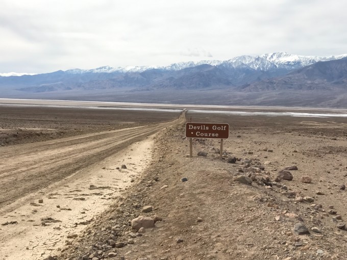
Death Valley has several iconic attractions: Bad Water Basin, Golden Canyon, Zabriskie Point,Devils Golf Course Follow the navigation.
Note: enough water ! ! Don’t be too heavy, it is very necessary! It is recommended to prepare 1L per person, and prepare some food supplies, such as chocolate. The water resources in the scenic area are extremely tight, so there is no water supply, and there is no canteen. All water and food need to be prepared in advance.
Change your sports shoes! Never wear sandals! Although the whole shoe was full of sand when it came out, it is better than being burned to death by sand It’s more troublesome, pay attention to the condition of the fuel tank! ! !
Arrive at BadWater, the ground is covered with white salt. The front is a wide field of vision, and the back is a layer of mountains, not only lamenting the magnificence of nature.
On the way back, we passed another scenic spot, Devils Golf Course, which is also a salt crystallization site. The intersection was blocked, and the car couldn’t drive in, so we didn’t go in.
Driving back to Las Vegas , the giant cactus next to the gas station. I flew back to Michigan
from Las Vegas . At this time, the heavy snow in Michigan is completely different from Las Vegas. Goodbye, I will go again the ~