
At the end of the fifteenth century, Columbus discovered the American continent and mistook it for India , so he also called the local aborigines Indians . Spain The Chinese language is “Indios”, and later generations will continue to use this name by mistake, and the Chinese transliteration is “Indios”.
In the middle of the nineteenth century, the U.S. government introduced the Reservation System for the aborigines, which empowered the government to set aside a place on the land that the aboriginal tribes have inhabited for generations, that is, a reservation for the tribe members to live and live. The land is under the supervision of the government. Tribal members are not allowed to leave the reservation at will, and outsiders are not allowed to enter without authorization. The aboriginal land outside the reservation was taken away by the US government and white people without compensation! Look, what is the nature of this system? Looting of Aboriginal land, racial discrimination and segregation! I really don’t know how Uncle Sam, who always prides himself on freedom, equality, and fraternity, proposed it in a grandiose and brazen way!
In the United States There are many such reservations in the Midwest and Alaska , and there are also several states that have been involved in this trip, large or small. The largest is in Arizona , such as the West Some of them are located in tribal reservations, and their development and management rights and income are owned by the tribes in the reservations. The South Rim of the Grand Canyon we went to and the North Rim are outside the reserve, which together form the Grand Canyon National Park and are owned by the federal government.
- From the Grand Canyon to Peggy, visit the Upper Antelope Canyon
At around 2:00 pm on July 22, we drove away from the east gate of the Grand Canyon National Park and headed for Page along the AZ-64 highway.
The car is not far away, there is a small Colorado River Valley scenic spot on the left side of the road, enter and park after donate 10 dollars at the gate set up by the Indians, and follow the signs to the river.
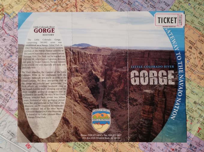
The brochure introduction (also tickets) given by , this is a Navajo Tribal Park (Little Colorado River Navajo Tribal Park), the main sightseeing content is the Little Colorado River Gorge (Little Colorado River Gorge) and some surrounding trails.
Is turbid and yellowed, and the rocks on both sides of the bank stand upright, which is extraordinarily wild against the background of the deep blue sky.
The fine limestone cliffs on the upper layer are closely connected with the huge sandstone structures on the lower layer. Look at the introduction, this is the geological evidence to prove that this place was once a sea in ancient times.
Turn into the US-89 highway, driving in a small basin, with yellowish gravel outside the window, and occasionally some small bushes.
Occasionally, I can see a few board houses, a few tents, and some pickups , motorcycles, and horses scattered around. I don’t know if it’s a gathering place for Indians.
The terrain is getting higher and higher, we drive from the bottom of the basin and turn left and turn right to climb up the edge of the basin.
From the east gate of the Grand Canyon, it takes about two and a half hours to arrive at the Antelope Canyon reception near Peggy. What you see is a piece of yellow sand under the scorching sun, a board house, and a sunshade! After asking the staff, there was only the last tour at 5:30 in the afternoon, and it was 63 dollars per person, which really made my heart ache! But isn’t it just for that dazzling phantom? Buy tickets and wait!

Time is up, get on the Hummer, fasten your seat belt, and run for 20 minutes on a road with yellow sand blowing across your face, it’s hard to tell whether it’s a valley or a river valley.
According to the online statement, the most filming is at noon, and our time is obviously a bit short. However, with the guidance and help of the tour guide, there are a few photos worth seeing!
Antelope Canyon is a masterpiece of flowing water! Although the plateau is hot and dry, there are frequent storms and heavy rains. The torrential rain forms a river, and the river water is wrapped in sand and gravel, and flows down the rock wall tightly. shaped texture.
The tour guides in our group were very good. At the end of the canyon, they did not return the same way as the other groups. Instead, they took us out of the canyon, climbed up the hillside, and overlooked the Antelope Canyon from the top of the slope. Then it came out from another small canyon. Afterwards, my wife joked that this Indian guy is really nice. If I hadn’t been told not to bring anything except a camera before the visit, including purses, wallets, etc., I would have tipped the guy.

I stayed in Peggy settling down, I found a restaurant opposite the hotel. Salad , main course, after-dinner snacks and beer, I had a crazy meal.
- Horseshoe Bend, Lake Powell and Glenn Dam near Page
There is also a small tidbit in Peggy : because I didn’t notice that there is an hour’s time difference between Arizona and California and Nevada in front, the next day (July 23) morning, the mobile phone clock still rang according to Los Angeles time, so everyone got up early After 1 hour, when I went to the restaurant for breakfast, I saw that there was no one there, so I realized it.
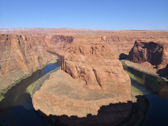
Horseshoe Bend (Horseshoe Bend) is near Peggy. We start from the hotel, go out of the town, go west, and drive for 15 minutes.
Horseshoe Bay is a “wild scene”! A “wild” word lies in the fact that there are basically no traces of man-made construction, no safety protection facilities, and no tickets are charged for unattended. The word “scenery” lies in the fact that the Colorado River cuts a deep valley here, and the turquoise water surrounds the brick-red giant rock, making a 180-degree turn. The bend is big and round, shaped like a horseshoe, which is very shocking!

Although it’s only 8 o’clock in the morning, it’s already very hot. The high temperature warning sign near the parking lot.
Going to Horseshoe Bay, you have to turn over a small hill, which is full of sandy soil roads, and it is a bit strenuous to walk.
Unfortunately, the direction of the light is wrong in the morning, the shadow blocked the river at the bottom, and the effect was not shown, let’s pay for it. Danyan and clear water, spectacular atmosphere! I regret not coming the night before.Lake Powell and the Glenn Dam are in the northwest of the town, and it takes 15 minutes to walk from the Horseshoe Bay parking lot to the direction of the town.
Gelan Dam, the height of the dam is more than 210 meters, and the length of the arched top is more than 400 meters. Just look at the little people on the top of the dam to know its size.
The dam is built across the terrain with the help of the topography of the Glen Canyon, and the walls of the canyon are steep.
Overlooking the bottom of the dam, the generator room is horizontally arranged, and the river flow is gentle.
It seems to be related to Mrs. Lyndon Johnson, the 36th President of the United States, “dedicated by” is not sure how to translate it here.
Powell Lake is an artificial lake formed by intercepting and storing water from the Glenn Dam. The roaring, rebellious Colorado River has lost its hostility here, and is as graceful as a virgin, blue, slightly rippling, peaceful and tranquil.
A schematic diagram of the surrounding adventure tour at the @Visitor Center. There are many national parks, tribal parks, and protected areas, including the Grand Canyon, Antelope Canyon, Monument Valley, Arches, etc. in our itinerary.
- Monument Valley
Leaving Glenn Dam at about 9:30, re-crossing Peggy Town, along US-160, US-163, passing Kayenta (Kayenta), driving 170 kilometers, arriving at Monument Valley Navajo Tribal Park at about noon (Monument Valley Navajo Tribal Park)
The sky is high and the clouds are light along the way, which makes people feel refreshed.
The lonely peaks and terraces on the side of the road in the distance gradually gather into pieces, the destination is almost here, get off the bus and check in.
Monument Valley Tribal Park is located in the northeast corner of the Colorado Plateau, about 46 kilometers away from the Kayenta. It is an area of giant peaks, buttes, and terraces formed by sandstone. Because the sandstone is rich in iron oxides and manganese oxides, it appears fiery iron red or cool gray blue. Against the backdrop of the blue sky, as far as the eye can see, sharp peaks, buttes, and terraces with huge color contrasts rise from the vast, desolate and barren gravel ground. , The feeling of desolation and excitement! No wonder, it has not only become the spiritual home of the Navajo tribe, but also the location of many Western films! The most famous ones are “Forrest Gump” and “Windtalker”.

Turn right from US-163, come to the park entrance, 20 knives per car to enter the park (tribal park, national park annual pass is not good).
Such a feeling place makes our desire to take pictures out of control! Ever since, the cameras and mobile phones came into battle, shooting wildly with various backgrounds and poses! Not to mention, there are a few really good ones, and one of them was posted on the photo wall when I got home.
Drive along the road in the scenic area to enjoy it at a close distance. The road was unpaved, with ups and downs and bumps. Thanks to the Cherokee, it was born not to take the usual road, and it was easy to deal with it. A few cars will be miserable, or they will rub the chassis and move forward with injuries, or they will hesitate and go home.
By the way, Cherokee, Chinese translation Cherokee, is a branch of North American Indians living in North Carolina, South Carolina and Tennessee United States today. Its reservation is near the Great Smoky Mountains National Park in North Carolina. In the reservation There are about 10,000 people living there. like a castle, the front is a tall tower.

There is also a small memorial hall dedicated to the story of “Wind Talkers”: During the Pacific War, 29 young Navajo tribesmen were conscripted into the army as translators and dubbed “Wind Talkers”. They transmitted information and issued combat orders in a tribal language that was difficult for outsiders to understand, so as to avoid being intercepted and deciphered by the Japanese army. Because they hold military secrets, each Windtalker is accompanied by a soldier, who is not only their protector, but also the terminator in times of crisis, which is embarrassing!