
The United States attaches great importance to the protection of the natural ecology of national parks, and large areas of undeveloped areas give people a chance to return to nature. These sleeping “historical treasure houses” show the world the exquisite shaping power of nature and preserve an undisturbed pristine pure land for people.
Since the world’s first national park (Yellowstone National Park) was established in the United States in 1872, 59 national parks of various shapes have emerged on the land of the United States in more than a hundred years. These sleeping “historical treasure houses” show the world the exquisite shaping power of nature and preserve an undisturbed pristine pure land for people.
The United States attaches great importance to the protection of the natural ecology of national parks. Large areas of undeveloped areas give people a chance to return to nature. Various hiking trails, boating, fishing and other activities show the love of Americans for natural sports, and also let tourists Experience a more pure American native life.
his article will introduce readers to three representative national parks:
Yellowstone National
ParkGrand
Canyon
National
ParkGreat
Smoky Mountains National Park
These three national parks not only preserve a highly complete ecological environment, but are also outstanding examples of certain natural resources (eg: canyons). The article will detail the transportation, characteristics, representative attractions and practical information of the three major national parks, and provide practical help and guidance for tourists who plan to go to the three major national parks. A list of other popular national parks in the United States is also attached for more choices.
Yellowstone National Park Yellowstone National Park
Yellowstone National Park is located in Wyoming (Wyoming) in the northern part of the United States. As the world’s first national park (established in March 1872), it has a rich landform style. Large coniferous forests, deep canyons and waterfalls flying down. 99% of the undeveloped area makes Yellowstone known as “the last wilderness”, giving tourists an undisturbed natural pure land.
It may be difficult for you to imagine that Yellowstone National Park itself is a giant volcano. This super volcano breeds many geysers including the Grand Prism. Interesting microbes turn each spring into stunning colors, giving Yellowstone an irreplaceable view. The rich natural landforms breed a large number of wild animals. Groups of bison, reindeer, chipmunks and Canada geese can be seen everywhere, providing tourists with a rare opportunity to watch wild animals up close.
how can I get there
There are two most convenient ways to go to Yellowstone National Park: by car and by flight. Either way, you need to start from Salt Lake City: b>. Salt Lake City is the closest big city to Yellowstone National Park, which has more advantages than other areas.
self-driving
There are frequent flights to Salt Lake City from major cities in the United States. Tourists can rent a car at Salt Lake City Airport and then drive to Yellowstone National Park. The fastest time from Salt Lake City to Yellowstone is about 5 hours. If you want to go east through Grand Teton National Park (Grand Teton National Park), you need to spend an extra 2 hours.
route
Yellowstone Airport is located on the west side of the national park, and it only takes 5 minutes to drive to Yellowstone. There is only one flight route at the airport, daily to and from Salt Lake City, and the flight time is 1 hour. This is also the fastest way to travel to Yellowstone National Park.
Yellowstone Airport has car rental counters, including Avis, Budget, and Big Sky, three agencies that can rent cars. Tourists who can’t stand the 5-hour self-driving can take a flight to Huangshi Airport first, then rent a car or report directly to Huangshi for a 1-day tour itinerary.
yellowstone zoning
There are 5 entrances to Yellowstone National Park, and most tourists will choose to enter and exit from the West Entrance. West Gate is adjacent to West Yellowstone Town (West Yellowstone), which is also the main accommodation area for tourists.
The interior of Yellowstone is divided into upper and lower loops . A typical figure-of-eight shape connects the most classic attractions of Yellowstone Park. It takes 6-8 hours for each loop to drive by yourself. It is recommended to drive only one loop a day, and the time is more appropriate.
Upper Loop
Most of the Upper Ring Road is dominated by high mountains and canyon roads, with a high altitude, and there are many viewing platforms overlooking the distant mountains. It is recommended that tourists drive counterclockwise on the Upper Ring Road , so that not only can the energy-intensive canyon be placed at the beginning of the day, but also the outer lane can be used on the high mountain section, which is convenient for parking and taking pictures.
(The order of attractions is arranged counterclockwise)
Grand Canyon Canyon Village
Here is the most stunning canyon landscape in Yellowstone National Park. For tens of thousands of years, the erosion of the volcanic rock formations by the river water has formed such a majestic scene today. The Yellowstone River pours down between the canyons and flows meanderingly, shaping the deep Yellowstone Grand Canyon. Down two raging waterfalls.
Lower Falls of the Yellowstone: b> is the finishing touch of the Grand Canyon, both in terms of height and canyon scenery. Many viewing trails along the Grand Canyon provide tourists with excellent viewing angles. One of the most representative viewing places is located at the Artist Point (Artist Point: b>) on South Rim Drive. If you want to enjoy the waterfall on the North Rock of the canyon, you can choose Lookout Point. The downhill trail at this viewing point allows you to walk all the way to the bottom of the canyon and take a photo with the waterfall at close range.
Lamar Valley
Lamar Valley is located in the northeast of Yellowstone and is the only place to enter Yellowstone from the Northeast Gate. This is the best place to explore wild animals in the park. The wide grassland and superior ecological environment have bred a wealth of wild species. Herds of bison roam the grasslands, and the occasional bighorn sheep and mule deer need to be observed by tourists. Wild animals are not only the “masters” of Yellowstone Park, but also an important part of local culture, injecting fresh energy into this pristine nature.
Mammoth Hot Springs
Mammoth Hot Spring is the largest carbonate sedimentary hot spring in the world. Its biggest feature is that it is stepped and flows slowly from top to bottom. Numerous springs flow down from the hillside section by section, and are colorfully dyed by various microorganisms. This also makes Mammoth Hot Springs look like a small “Cotton Castle”, crystal clear.
Norris Geyser Basin
Norris Springs, located on the southwest side of the Upper Ring Road, is a collection of the most active and unstable geysers. In the large geyser basin, visitors can see colorful geysers of all kinds. Along with the continuous emergence of new springs, these springs are also accompanied by the gradual drying up of old springs (white), and the cycle of transpiration and change.
The Steamboat Geyser, the highest erupting geyser in the world, is also located here. Its energy storage period is very long, and there is no regular eruption time. It only erupts once every few years, but the height of each eruption is astonishing, with the highest record reaching 91 meters. It last erupted in September 2014.
Lower Loop
The Lower Ring Road contains many of the best attractions of Yellowstone Park. The altitude here is relatively low, and many high-quality attractions including the Grand Prism, Old Loyalty and Yellowstone Lake have been bred here. The Lower Ring Road is also a popular route for sightseeing. If you only have one day, it is recommended to choose the Lower Ring Road.
Since the big prism, old loyalty and other popular attractions are on the west side of the lower ring road, if tourists enter the park before the peak passenger flow at 10 o’clock, it is recommended that tourists travel counterclockwise and go to the popular attractions first. If you enter the park after 10 o’clock, it is recommended to play clockwise. In the afternoon, the passenger flow of the Grand Prism and Old Loyalty is relatively small.
(The order of attractions is arranged counterclockwise)
Caiguoquan Fountain Paint Pot
The area where Caiguo Spring is located has the most geyser springs in Yellowstone Park. From a distance, the whole area is emitting steaming heat. Groundwater is very important to the formation of hot springs, and the water sources at the foot of the mountain are more abundant, which also allows tourists to see all four types of hot springs in Caiguoquan: mud springs, geysers, hot springs and jet air.
These springs with rich colors and different shapes are like overturned seasoning plates, dyeing the land around the springs with rich colors, and they were named “colored pot springs” in ancient times.
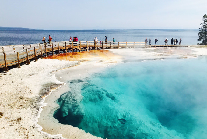
Grand Prismatic Spring
The Grand Prismatic Spring is the “signboard” of Yellowstone Park and the most eye-catching color of the whole park. As the largest spring in the United States, the width of the Grand Prism is astonishingly 91 meters, so that you can’t get the whole picture of the Grand Prism when you stand in front of it. The abundant microorganisms in the spring water give the spring water a striking color, from deep blue to brilliant orange red.
There are two trails to visit the Grand Prism. Most tourists will choose to go to the Midway Geyser Basin (above), which is also the place to see the Great Prism up close. Of course, you can only see the near view of the large prism and not the whole view. To see the panorama, you need to go to the trail in the picture below. The trail has no name and the entrance is not obvious, so be careful not to walk through it.
Old Faithful Old Faithful
Old Faithful Spring, just like its name, is a geyser that repeats itself with regular eruptions. On average, it erupts every 1-2 hours. The water column is more than 30 meters high, and within 2-5 minutes of eruption, the hot spring of nearly 100 degrees is thrown into the air.
Old Faithful has erupted regularly for more than 200 years, and because of this, people have gradually mastered its regular eruption cycle. Thus, the exact moment of each eruption can be calculated. Whenever the time is approaching, there are always a large number of tourists gathered here, ready to see the spout of Old Faithful.
West Thumb Geyser West Thumb
The West Thumb Geyser is located at the southeast corner of the Lower Ring Road, next to Huangshi Lake, and is the only place in the park with a geyser and a lake view. The Blue Pool and Abyss Pool in West Thumb are sky blue, and the blue pool water is very suitable for taking pictures. Walking on the wooden plank road on the seashore, one side is the endless lake water, and the other side is the transpiring West Thumb Spring, forming a wonderful lakeside scenery.
Yellowstone Lake
Yellowstone Lake is the largest inland lake in the park and the source of the longest river in the United States, the Mississippi River. Incredibly, the entire Yellowstone Lake is actually the center of Yellowstone’s active volcano, from which the volcanic rock that covers the entire park erupts. Walking by the lake, you can find that the color of the lake is constantly changing, which is also a sign that the hot springs at the bottom of the lake are constantly gushing out.
Yellowstone Lake can experience kayaking or take a sightseeing boat tour around the lake.Visitors can go to Bridge Bay Marina (Bridge Bay Marina) to learn more.
Featured Experience
Discover Wildlife Animal Watching
There are a large number of wild species living on the vast land of Yellowstone. These “masters” of Yellowstone have multiplied here for generations, not only following the survival rules of nature, but also presenting the most primitive side of Yellowstone to tourists.
The best area to explore wildlife is on the east side of the park, where the meandering Yellowstone River breeds vast pastures. From Lake (Lake) all the way north to Lamar Canyon (Lamar Velley):b>, it has formed an excellent area for wildlife survival. Among them, the American bison is the focus of tourists. As the national animal of the United States, its shocking scene in groups is the expectation of many tourists. In addition, moose, bighorn sheep and black bears that appear and disappear from time to time are also wild species that can often be seen in Yellowstone Park.
Hiking
In the vast wilderness of Yellowstone Park, there are more than 1,000 kilometers of hiking routes. These hiking routes give tourists the opportunity to return to nature, and they are also a favorite form of exercise for local American tourists. For tourists, it is most convenient to choose a hiking route near popular attractions.
If you want to see the scenery of popular attractions during the hike, then these three hiking routes will not disappoint you.
The Grand Prism Hiking Route (see the Great Prism Scenic Spot Map on the Lower Ring Road for the entrance): You can take a panoramic view of the Grand Prism, and the round trip takes about 40 minutes.
Lookout Point Trail in the Grand Canyon: A hiking route to the lower end of the canyon that allows you to look up at the magnificent waterfalls up close. It takes about 30 minutes to go back and forth, and most of the routes are up and down steps.
Continental Divide Trail at Old Faithful: You can see popular attractions such as Morning Glory Pool and Giant Geyser. The round trip takes about 1 hour.
For more walking advice, please refer to
Precautions for hiking
Avoid walking at night
. Yellowstone’s hiking trails are surrounded by large undeveloped forests, where black bears and wolves often appear. There are no security measures at night to ensure the safety of tourists.
It is recommended that at least 3 people walk together in the park to take care of each other.
Carry bear spray (Bear Spray):
Even in the daytime, black bears often appear on the hiking trails, and black bears are extremely dangerous. In any case, it is necessary to keep a distance of more than 30 meters from it. It is recommended to carry bear spray when entering the hiking route to ensure personal safety.
Stay away from springs
Some hiking trails are flanked by geysers, which appear to be lifeless. However, it generally contains extremely high corrosiveness and high temperature, so do not touch it.
Practical information
best time to travel
The best time to travel to Yellowstone is from May to September every year, when the temperature is comfortable during this period. But hotels near the park are more expensive and nearly full. If you plan to go to Yellowstone Park during the peak season, you need to make an appointment as soon as possible. Autumn in Yellowstone Park comes earlier, and you can usually see colorful autumn scenery from mid-September.
Yellowstone in winter has a long freezing period (December to March of the following year), the roads are covered with heavy snow, the weather is freezing, and there are very few tourists. The park is closed to private vehicles during this time. Visitors can only enter the park by snowmobile, snowbus, or snowboard.
ticket fee
Tickets for Yellowstone Park are valid for 7 days, and visitors can enter and leave Yellowstone Park at will within 6 days after entering the first day with tickets. Yellowstone Park and Grand Teton Park have passes. If you want to visit both parks at the same time, you can buy a pass (Both Park Ticket) directly at the entrance.
stay
There are several scenic spots in Yellowstone National Park
with large hotels, including Mammonth, Old Faithful, West Thumb, Lake Village and the Grand Canyon ( Canyon): b>. The advantage of these hotels is that they are in Yellowstone Park, so they don’t have to drive in and out of the park every day, saving a lot of time. However, the hotel prices in the park and the tips in the restaurants are really a lot of expenses.
West Yellowstone Town (outside the park)
West Yellowstone Town (West Yellowstone), located on the west side of the park, has more accommodation options. The price here is not as expensive as the hotels in the park, and there are many souvenir shops and delicious restaurants worth visiting. . But it takes at least 1 hour to go back and forth between the town and the park every day.
Precautions for visiting the garden
Avoid walking at night
Most tourists will return to their residences before dark. There are no street lights in the park at night, and the dark night roads are winding and difficult to walk. The presence of animals adds to the uncertainty.
Traffic jam section
Every time you encounter a road section with heavy traffic jam, it proves that there are animals infested at the front end of the road. When the vehicle gives way to the animals, it will also stop to take a few photos. Tourists in every car do this, forming a spectacular traffic jam.
Changes in temperature difference
Yellowstone Park has a large temperature difference between morning and evening. During the peak season, the temperature during the day can reach 30 degrees, but it will drop below 10 degrees at night and early morning. Pay attention to adding or removing clothes.
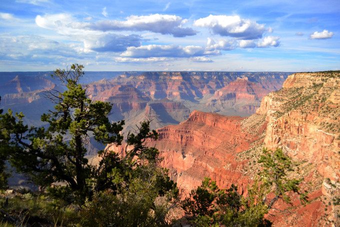
Grand Canyon National Park
The Grand Canyon of Colorado, formed by the erosion of rivers for thousands of years, is located in Arizona in the southwestern United States. The deep gullies of more than 1,000 meters and the majestic and cascading cliffs make the Grand Canyon a model of American canyon landscapes. Standing on the edge of the canyon, you can feel the magnificent scenery shaped by the river’s cutting and erosion for thousands of years.
Most of the tourists who come to the west of the United States by car will include the Grand Canyon in their itinerary planning, and the numerous one-day tours in Las Vegas, the casino city, make it easy for tourists to go to the Grand Canyon.
grand canyon zoning
The Grand Canyon is mainly divided into three parts: the West Gorge, the South Gorge, and the scenic spots around the canyon . They are far away from each other and relatively independent. It takes at least 1 day to go to any one. The canyon landscapes of Xixia and Nanxia are relatively homogeneous, so it is recommended to choose one of the two.
The West Gorge is most suitable for a 1-day tour in Las Vegas, and the South Gorge is more suitable for tourists who have plenty of time and drive by themselves. The scenic spots around the canyon are mainly famous for Antelope Canyon and Horseshoe Bend: b>, both of which are around the small town of Page, and are popular places for tourists to “check in”. Tourists can choose to take a 1-day tour in Las Vegas, or drive there together with the South Gorge.
Grand Canyon-Parashant National Monument
The West Gorge of the Grand Canyon is also known as the “Walapai Indian Reserve”. This area is controlled by the aboriginal Indians and is the closest Grand Canyon to Las Vegas. The West Gorge is suitable for tourists who are not self-driving and have limited time. If you sign up for a 1-day tour in Las Vegas, you can easily go to the Grand Canyon.
The development of Xixia is relatively complete, from landmark attractions to unique experiences, and tourists rarely need to worry about following the guide. Since West Gorge is the closest to Las Vegas, it is also the main destination for one-day tours and group tourists. It is convenient and accompanied by a certain degree of commercialization.
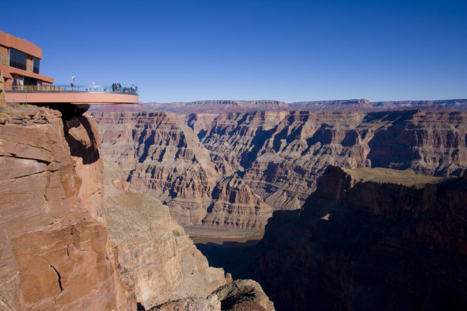
Grand Canyon Skywalk Grand Canyon Skywalk
The Sky Trail is the iconic scenic spot of Xixia. The entire U-shaped glass trail is built on the edge of the cliff of the Grand Canyon, and the farthest protruding trail is 20 meters away from the cliff. The fully transparent trail gives tourists the opportunity to “hang” over the canyon and overlook the abyss at the bottom of the 1,200-meter valley.
The trail needs to be purchased separately, and the price is 21.65 US dollars (about 140 RMB). Before entering the trail, tourists need to store their personal belongings. Cameras, mobile phones and other photo equipment are not allowed to carry. The staff will take pictures for you at the best spots, but of course you need to pay at least $20 (about 130 RMB) to get it.
Eagle Point
Eagle Rock is located next to the Skywalk, and it got its name because the rock wall on the other side resembles the wings of an eagle. This is a great place to take photos with the deep canyon and the Skywalk beyond. Standing on the edge of the canyon, the famous “Eagle Peak” is in front of you, and the canyon and the Colorado River are more than a thousand meters below your feet. The naturally formed “Eagle Peak” is a gift from God to the Indians and an outstanding work of nature.
Bat Rock Guano Point
Bat Rock is located in the north of the Grand Canyon and is the highest viewing point in Xixia. Different from other locations, Bat Rock is located at the bend of the river, forming a protruding rock wall. This allows tourists to have a wider view of the canyon, and it is also the best perspective to appreciate the West Gorge.
Hualapai Ranch
A ranch with a typical American-Western style, wooden cottages with a sense of age, and various Indian cultural decorations bring tourists back to the Western gold rush era. Tourists can ride horses and browse souvenir shops here. The ranch area is small, and the items that can be experienced are also very limited.
But it is worth mentioning that the Hualaipai Ranch provides accommodation, and several cabins beside the ranch have become a good choice for tourists to stay in Xixia. If you don’t mind living without a signal for one night, you can enjoy the first-class starry sky and the stunning sunrise and sunset views of the canyon here.
Featured Experience
West Gorge has two well-developed experience projects: helicopter and Colorado River sightseeing boat . The two experience projects provide tourists with the opportunity to overlook the canyon from the air and look up from the bottom of the canyon. The 20-minute helicopter canyon sightseeing experience is priced at US$107 (about 700 RMB), and the experience price of helicopter + sightseeing boat is US$202 (about 1300 RMB).
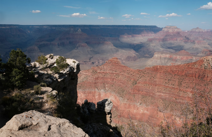
Grand Canyon National Park (South Rim) Grand Canyon National Park
The South Gorge is actually the real Grand Canyon National Park. The canyon here runs east-west along the Colorado River, showing quite amazing canyon levels and more primitive canyon landforms. This is different from the “check-in tour” mode of Xixia. The vast area allows you to have more experience of hiking and overlooking the canyon, allowing you to return to nature. Most of the tourists who come to Nanxia will choose to drive by themselves, and transfer to the park bus in the park to go to various viewing spots.
Nanxia has complete service facilities, sufficient parking lot, restaurants and a service center that can provide you with all information, adding multiple conveniences to tourists. Nanxia Park has its own resort center, and the hotels here are specially suitable for tourists who want to watch the starry sky and sunrise without going camping.
How to start the tour of the South Gorge
Finalize travel time
The depth of playing in the Grand Canyon determines that you need to stay here for a few days. If you only want to go to a few viewpoints, then a half-day to 1-day itinerary will do. If you want to watch the sunrise and the starry sky, it is best to stay for one night. If you want to experience the Grand Canyon more deeply and take a hiking route, it will take at least 2-3 days.
Grand Canyon Visitor Center Visitor Center
The service center can provide tourists with all support in terms of information. Tourists can not only get a map here, see the sunrise and sunset times of the day, but also directly ask all questions about the Grand Canyon to the information desk. These staff will plan your itinerary reasonably for you according to your time. Including which viewing spots are most worth visiting, today’s sunset time and some hiking routes for you. So if you want to learn about the Grand Canyon and plan your itinerary in the shortest time, it is right to come to the service center.
Most self-driving tourists will choose to enter from the south gate of the Grand Canyon (Tusayan), and the nearest tourist service center after entering the south gate is the Grand Canyon Visitor Center. Visitors staying in the Grand Canyon Viliage on the west side can choose to go to the closer Verkamp’s Visitor Center.
Park bus
After tourists arrive at the Grand Canyon National Park by car, the four free park buses that shuttle between various areas become the main means of travel for tourists. The Grand Canyon is in the southwest direction, and the four routes are evenly divided into various parts and connected with each other.
Some scenic roads (Hermit Road, Yaki Point Rd) are not open to private cars and are only used by park buses. The four lines are distinguished by color, namely orange line, blue line, purple line and red line. Among the four bus lines, except for the red line, the other three lines start from the Grand Canyon Visitor Center (Grand Canyon Visitor Center). Tourists who want to transfer to the red line need to take the blue line here to transfer to Village Rouye Transfer.
operation hours
Route Details
Orange Line Kaibab/Rim Route
The Orange Line is close to the Grand Canyon Visitor Center and several famous viewing spots around it, and is the most frequently used and most important line in the scenic spot. For tourists who only have half a day, the attractions on the Orange Line are the essence of the Grand Canyon and can be used as the first choice . Notable sites include Mather Point, Geology Museum and Yaki Point.
Blue Line Village Route
The blue line is the longest line in the Grand Canyon. It mainly connects the Grand Canyon Resort (Village) on the west side: b> and transfers to various lines in the east. It is also the only one that can transfer to the red line (see sunrise and sunset) lines . All tourists staying in the hotels in the Grand Canyon Resort need to use the blue line to get back and forth. Due to the many stops on the blue line, it takes about 20-30 minutes one way from the Grand Canyon Visitor Center to the hotels in the resort.
Red Line Hermits Rest Route
The red line is located on the westernmost side of the Grand Canyon, and can be transferred at Village Rouye Transfer through the blue line. The red line is mainly provided for tourists who want to watch the sunrise and sunset. Mohave Point and Hopi Point along the way are excellent places to watch the sunrise and sunset. Roads passing through the Red Line are open to private vehicles from December 1 to February 28 each year.
Purple Line Tusayan Route
The purple line is mainly responsible for sending tourists from the Grand Canyon Visitor Center (Grand Canyon Visitor Center) to the southern tourist town of Tusayan (Tusayan): b>. Summer resorts are often overcrowded with tourists, and the small town of Tusa Field in the south has become a popular choice for tourists to stay. The Purple Line is only open from May 7th to October 9th each year. The pick-up location is the Grand Hotel in Tusa Field. 20 minutes one way.
Grand Canyon Top Attractions
Mather Point & Geology Museum (orange line)
Mather Point is adjacent to the Visitor Center (GCVC). It takes only 5 minutes to walk from the Visitor Center without taking the park bus. This is the first time most tourists see the Grand Canyon. There are complete guardrails and trails on the edge of the canyon, allowing tourists to easily stand on the edge of the canyon and take photos. The Geology Museum is a museum that understands the canyon’s landforms. It clearly records the causes of the canyon, allowing visitors to have a deeper understanding of this stunning scene.
There is a well-paved hiking section from Mather Point to Geology Museum, which takes about 15 minutes. During the period, you will pass by several viewing platforms and viewing points overlooking the canyon. It is recommended that tourists do not need to stay at Mather Point for too long. Since this viewing platform is full of tourists who have just seen the canyon, it is the most crowded. The observation deck at the back has relatively fewer tourists and a wider field of vision.
Mohave/Mojave Point (red line)
Mohave Point is located on the west side of the canyon and is known as the best place to watch the sunrise and sunset in the Grand Canyon. The Grand Canyon will show multiple colors at sunrise and sunset. Feeling the color change between the canyons is also a must experience in the Grand Canyon. The visitor center will record the sunrise and sunset times of the day in detail. If tourists are located in the east of the canyon, it will take at least 40 minutes to reach the viewing spots on the west side by taking the park bus.
Desert View (self-drive)
Desert View is located on the east side of the Grand Canyon, next to the entrance to the east side of the Grand Canyon. It is famous for an ancient all-stone pagoda built in 1930 on the edge of the cliff. At the same time, you can also clearly see the sight of the Colorado River meandering through. Since the viewing point faces the west, it becomes the best place for tourists to enjoy the scenery at sunset. The park bus does not pass through Desert View, so you need to drive there. If you plan to travel to Horseshoe Bend and Antelope Canyon via Route 64, this viewing point can be dropped by.
Featured Experience – Walking
Picture: The required equipment for the third-level difficulty trail of the Grand Canyon. By Mafengwo Raiders Editorial Department
Hiking is not only a form of exercise that Americans like, but also an excellent way to experience the Grand Canyon in depth. The hiking routes in the Grand Canyon National Park are divided into three levels according to the difficulty: Easy, Moderate and Difficult. For ordinary tourists, it is most suitable and easy to participate in simple-level hiking routes.
Simple level Easy
Trail name: Rim Trail
This hiking route extends from Pipe Creek Vista in the east of the Grand Canyon all the way to Hermits Rest in the west. The whole journey is 20 kilometers, built along the edge of the canyon, and contains the most exquisite scenery of the Grand Canyon. The hiking trails are flat and spacious, no equipment required, and suitable for tourists of all ages. Most tourists will choose one of the experiences, and then find the nearest park bus stop to return to the visitor center.
Moderate
Trail name: Bright Angel Trail
is one of the most popular hiking routes for tourists in the United States. It provides a hiking route deep into the bottom of the canyon and close to the Colorado River. The line is divided into many sections, and the round-trip time ranges from 4-12 hours. If you want to camp on the Colorado River, you need to apply to the visitor center in advance.
Difficulty level Difficult
Trail name: Grandview Trail/Hermit Trail
Difficult hiking trails have steeper and undeveloped canyon roads, and each trail takes about 4-9 hours. This level has higher requirements for hikers, who need to have hiking experience and wear hiking clothes, shoes and equipment.
Practical information
way of arrival
Most tourists will choose to drive to the South Gorge, starting from Las Vegas, passing through the Hoover Dam (Hoover Dam), the small town of Kingman (Kingman), and finally arriving at the South Gorge: b>. It takes about 4 hours without stopping. If you want to stop at the Hoover Dam and Kingman Town, you need to set aside an additional 2 hours.
Las Vegas also has a one-day trip to the South Gorge, the reference price is 80 US dollars (about 520 RMB). However, the round-trip 6-8 hour drive and the way of visiting the flowers on horseback really discourage many tourists.
ticket price
Tickets to the Grand Canyon are charged per car, $30 per car (about 200 RMB), including all tourists in the car. If you take the park bus to enter the Grand Canyon, the ticket fee is 15 US dollars (about 100 RMB) per person.
The ticket is valid for 7 days, and tourists can enter and exit the Grand Canyon at will within 6 days after entering the first day with the ticket. Self-driving tourists can stick their tickets on the car window to facilitate staff verification.
best time to travel
The Grand Canyon National Park is open all year round, with May-September being the peak travel season.
Accommodation information
Tourists can choose to stay in the resort (Village) in the Grand Canyon National Park, where there are several well-equipped hotels. The hotels in the Grand Canyon Resort are often fully booked during the peak season. Tourists can also choose the small town of Tusayan (Tusayan) located at the southern entrance of the canyon: b>, here is like a “supply station” for the canyon. There are not only many hotels, but also many Restaurant and souvenir shop. It only takes 20 minutes to drive or take the park bus to the Grand Canyon.
Precautions
beware of heatstroke
From May to September, the surface temperature of the canyon can reach over 40 degrees, making it easy to suffer from heat stroke. Stay hydrated, get plenty of rest, use sunscreen, and pay attention to sun protection. Drinking water devices are provided for tourists free of charge in the visitor center and grocery stores, and tourists need to bring their own water cups.
Pay attention to temperature changes
The daily temperature difference in the canyon changes drastically, and it is still unbearably hot during the day, and it will drop to only a dozen degrees at night, so you need to prepare warm clothes.
beware of summer storms
Storms occur frequently in summer. Although they pass in an instant, the accompanying violent storms require special attention. At that time, tourists need to stay away from the edge of the canyon and do not stand under the trees. Look for buildings or seek shelter by staying in your vehicle.
away from the cliff
There are only a few viewing platforms with guardrails beside the cliffs of the Grand Canyon, and most of them are exposed rock walls. Below the rock walls is a canyon of more than a thousand meters. Don’t go too close to the edge of the rock face, and don’t back away without seeing it clearly. Special attention needs to be paid to children for safety.
Tour around the canyon (Horseshoe Bend, Antelope Canyon)
Horseshoe Bend (Horseshoe Bend) and Antelope Canyon, located in the northeast of Grand Canyon National Park, have become popular places for many tourists because of their exquisite landforms. Both landscapes are near the small town of Page, and there are two ways to get there: 1-day tour or self-driving:
how to get there
1 day tour
Las Vegas has a large number of 1-day tour groups to Horseshoe Bend and Antelope Canyon every day. The reference price for a 1-day tour from Las Vegas to Horseshoe Bend, Antelope Canyon and Lake Powell is around 1,000 RMB.
self-driving
Self-driving is nothing more than the most convenient way to go to Horseshoe Bend and Antelope Canyon. Most tourists will drive to the small town of Page (Page) after visiting the South Gorge, and the drive takes about 2 hours. It is recommended that tourists rest in Page for one night, and then drive to Horseshoe Bend and Antelope Canyon the next day. The driving time between the two places is about 15 minutes from Page. If everything goes well, the trip between the two places can be completed in one morning.
Horseshoe Bend
The location of Horseshoe Bend is originally a very common channel of the Colorado River, but because of its unique U-shaped turn (270 degrees), it forms a shocking river canyon landscape. Standing on the edge of the canyon, the Colorado River is more than 1,000 meters deep at the foot, and the red canyon reflected in the sunlight forms an unmissable scenery.
Antelope Canyon
Antelope Canyon is a famous crevice-shaped canyon. The dry river channel is extremely smooth by the torrents. The unique red sandstone has left the graceful traces of these flowing water. When the sun shines into the crevice, it forms a wonderful “light and shadow world”.
Antelope Canyon is divided into upper and lower parts, although they are adjacent to each other, they are relatively independent parts. Visitors can only visit one area at a time. There is only one route to go in the Upper Antelope Canyon. Tourists follow the one-way route, go to the end and return the same way. Lower Antelope Canyon is a deeper canyon with more room to climb up and down.
How to Get to Antelope Canyon
Since the Antelope Valley is part of the Navajo Aboriginal Reserve, only the participating groups can enter the Antelope Valley. There are four or five local travel agencies that do Antelope Valley group tours. It is recommended that tourists make reservations on the website or by calling in advance. If you do not make an appointment in advance, you can also go directly to the Antelope Valley Visitor Center to register on the spot. However, the admission time and the number of places on the day are uncontrollable, so be prepared to wait for a long time.
Provide reservation website for Upper Antelope Canyon itinerary
Antelope Canyon Navajo Tours
Provide reservation website for Lower Antelope Canyon itinerary
Lower Antelope Canyon Tours-Dixie Ellis
Precautions
The walking space in the middle of Antelope Canyon is very narrow, with towering valley walls on both sides, so it is necessary to replenish water frequently to prevent heat stroke.
When entering the Antelope Canyon, there are often falling sand on both sides of the canyon. During this period, try not to look up at the canyon to avoid being confused. If you mind falling sand, you can bring your own mask.
You can see the sign of Flash Flood in Antelope Canyon. Monsoon floods often break out in this area in summer, and the Antelope Valley is at risk of being submerged in an instant. In case of rain during the tour, you must obey the leader’s arrangement and don’t panic.
Great Smoky Mountains National Park Great Smoky Mountains National Park
The Great Smoky Mountains National Park, with the largest number of annual visitors in the United States, is the “darling” of American tourists. As the last virgin forest in the eastern United States, the cloud-shrouded forest scenery is the signature of the Great Smoky Mountains. The rolling mountains are home to a large number of wild species, making hiking exploration a fun thing here. The mountains with dramatic altitude changes show colorful colors in autumn, which is the most suitable for enjoying autumn scenery. A winding road (US-411) traverses the core hinterland of the park, which is very suitable for self-driving tour. Driving on the road between the mountains, even if you don’t get off the car, you can enjoy thousands of scenery.
how can I get there
Great Smoky Mountains National Park is located in the eastern United States, on the border of Tennessee and North Carolina, and south of Georgia. It takes 3-4 hours to drive from big cities such as Atlanta and Charlotte. Since it takes a long time to drive from Washington DC to the Great Smoky Mountains, you may consider taking a flight.
The closest airport to the Great Smoky Mountains is Mcghee Tyson in Maryville, a 45-minute drive from Great Smoky Mountains Park. McGhee Tyson Airport has a wide range of routes, covering many tourist cities such as New York, Orlando, and Chicago.
Regional differentiation
The Great Smoky Mountains National Park has a vast area and can be divided into four main areas: cades cove, along Route 441 (US-441), Gatlinburg (Gatlinburg) and Cherokee (Cherokee): b>. A good understanding of these areas will help tourists grasp the essence of the park as soon as possible and plan their trip reasonably.
Cades Cove
Cades Cove is an open plain surrounded by mountains. Not only can you look up at the mountains here, but it is also the best place to watch wild animals in the park. Herds of white-tailed deer, strong North American black bears, turkeys, raccoons and other wild animals often come and go, swaggering past your car window.
Touring Cades Cove is mainly by car, and it takes about 2-3 hours to drive around along the Looping Road planned by the park. During the period, there are often stop and go or traffic jams, which also means that there are wild animals in front of you.
Route 441 (US-441)
Route 441 traverses the Great Smoky Mountains National Park, deep into the heart of the park. The stretching road criss-crosses in depth among the ridges, which is not only an excellent section for enjoying the autumn scenery, but also connects many of the best scenic spots in the Great Smoky Mountains.
The road starts from the small town of Cherokee in the south and ends in the famous city of Gatlinburg in the north. The whole drive takes about 1 hour. It is the choice of most tourists to stop and go on the road and enjoy the scenery of the mountains. If you want to go deeper, you might as well choose one of the hiking routes along the way to feel the fun of returning to nature.
Highlights along the route
Boundary monument Newfound Gap
Located in the middle of Route 441, Newfound Gap is the lowest point in the entire park and the dividing line between Tennessee and North Carolina. There are state boundary markers suitable for punching in, and it is also the starting point of the trekking trail to the highest peak of the Great Smoky Mountains, “Clingmans Dome”.
Clingmans Dome
GatlinburgGatlinburg
Gatlinburg is the gateway town to the northern part of the Great Smoky Mountains, next to the entrance to the northern part of the Great Smoky Mountains. With the largest number of hotels, it is the main accommodation for tourists going to the Great Smoky Mountains, and it is also the main stopover point from McGhee Tyson Airport (McGhee Tyson Airport) to the Great Smoky Mountains.
Pigeon Forge (Pigeon Forge), which is adjacent to Gatlinburg, is known as the “Las Vegas” of the East. Completely different from the original natural scene of Dayan Mountain, this is the capital of entertainment with neon lights. Row upon row of characteristic hotels on the main street, the popular Dollywood theme park (Dollywood), go-karts, escape rooms, and various magnificent performances give you plenty of reasons to stay here for a few more days.
Cherokee
The small town of Cherokee is the southern gateway of the Great Smoky Mountains. Tourists who drive from Charlotte and Atlanta to the Great Smoky Mountains will choose to stay here. Highway 441, which runs through the park, connects to the town, and it takes only a few minutes to drive to the Great Smoky Mountains. The town is close to the starting point of the Blue Ridge Parkway, which is known as a model for self-driving scenery in autumn because of its characteristics of crossing the mountains.
The small town of Cherokee was originally inhabited by Indians, and the Cherokee Indian Museum in the city center (Museum of The Cherokee Indian) shows this history to the world very well.
Tour around
Bryson City, a 15-minute drive from Cherokee, has two train sightseeing lines. These two loops go deep into virgin forests and river valleys, giving tourists a new perspective to explore the mysterious nature.
Featured Experience – Walking
There are a large number of hiking routes in the Great Smoky Mountains, and several classic hiking routes show the essence of the Great Smoky Mountains. See the table below for details.
Appalachain Trail
The classic hiking route in the middle of the park, the entire route is stuck on the dividing line between the two states (Tennessee and North Carolina), extending vertically and horizontally based on the dividing line. Newfound Gap is the starting point for two routes, one heading west and one heading east. The end of the westbound route is Clingmans Dome, the highest peak in the Great Smoky Mountains, and the eastbound end is the boulder Charles Bunion, which is suitable for overlooking the mountains.
Roaring Fork
The most popular hiking route in the park is the small loop just north of Gatlinburg. Tourists can drive along the Roaring Fork Motor Nature Trail, and they will see many hiking trails along the way. These trails include stunning waterfalls and natural ponds. Many tourists will choose to park their cars on the side of the road and walk into the quiet trails to explore nature.
Alum Cave Trail
The route shows visitors magnificent rock walls and caves along the way, and extends all the way to Mount LeConte, the park’s third highest peak. There is the only resort in the entire park on the top of the mountain, and the rooms are extremely popular and should be booked as early as possible. If you don’t want to go that far, you can take Alum Cave Bluffs halfway as the end of the hike, where the prominent rock walls and valleys form a natural haven for tourists to rest.
Chimney Tops Trail
The route rises to a height of more than 400 meters within three kilometers. The relatively steep hiking route and the unobstructed view of the mountain top attract many explorers. This section is suitable for climbers with hiking experience and professional mountaineering equipment. The mountain road is steep and unprotected, so tourists need to do what they can.
Practical information
best time to travel
The best time to travel to the Great Smoky Mountains is from May to October. The weather in summer is the best for outdoor activities such as hiking, and it is also a good time to see wildlife. The autumn of the Great Smoky Mountains begins at the end of September, and the best viewing period is October. The red leaves in the mountains show different colors according to the altitude, which is also the signature of the Great Smoky Mountains.
Ticket information
There are no tickets for the Great Smoky Mountains, and it is free to pass all year round. There is a $1 fee for maps or hiking trails taken at various visitor centers.
Precautions
watch your step
There are many streams in the Great Smoky Mountains, and the morning mist fills the air. The water vapor will cover the trails and rocks. If you arrange a hiking trip, pay more attention to your feet to avoid slippery roads and injuries.
anti-mosquito bites
The humid environment is very suitable for the growth of mosquitoes. Visitors who have hiking activities in the park are advised to wear stockings, do not expose their ankles, and spray anti-mosquito agents in advance.
keep away from wild animals
Wild animals are dangerous, so keep a distance from them, let alone feed them. It is recommended to carry bear spray with you in case of accidents.
A list of other popular national parks in the United States
In addition to these three major parks, there are many national parks worth visiting in the United States. The list is divided by region, providing tourists with a list of popular national parks in the west and east of the United States. Most of the national parks are concentrated in the west of the United States, and there are relatively few national parks in the east.