
The natural beauty of North America is displayed vividly in many national parks. When you go to the United States and Canada, do not miss these national parks.
Grand Canyon National Park
Grand Canyon National Park (Grand Canyon National Park) is located in Arizona, about 17 kilometers wide and 3000 meters deep. National parks in the United States are worth writing about in terms of geographical features, but the grandeur of the Grand Canyon is not. It takes effort to explain, because anyone can feel that this is the vicissitudes of life that has been left behind after hundreds of millions of years.
According to the research of geographers, the Grand Canyon has a history of 6 million years and is a masterpiece of nature on the earth. Americans are proud and proud of this. Apart from its majestic side, the Grand Canyon also has many winding paths with thousands of turns; the two cliffs stand thousands of miles, and the scenery holding a line of blue sky is amazing, and it will inevitably make you feel that the front is just in front of you. There is the brave man of Guan. There are other caves and rock valleys formed by the impact of water flow. The shapes and colors are as red as fire. Every rock seems to be a beautiful painting.
The stratum structure of the Grand Canyon National Park is loose and uneven, and the rampant river water sometimes causes a large area of collapse, sometimes leaving only a gap; The gentle traces below, such as the rolling of the torrent, produce abrupt ornamentation. As a result, this long canyon is mixed, some wide, some narrow; some like honeycombs; some like ant nests; some towering like pagodas, some piled up like bricks; some Such as lonely peaks, some like caves, people named these masterpieces of nature according to their shapes, and named them with names containing fairy tales. Among them, the “Angel Window” located on the north edge was originally a sky-opening cave that appeared on the mountain peak. Visitors have come to this point and are all in awe of the magic of nature.
The northern rim of the Grand Canyon National Park is more than 300 meters higher than the southern rim. The climate is cold and humid, the forests are green, and the scenery is stunning. However, there is no free bus here. You have to drive or walk by yourself, so compared with the southern rim, it is less visited by tourists. place. Because it is relatively remote and the road is blocked by ice and snow in winter, it is only open from mid-May to mid-October every year. When I drove here last year, I found out that there was still a week before the opening time, and I had to change the route to the south edge halfway. Today I finally have the opportunity to make up for this regret!
The heart of the North Rim is the Bright Angels district, which houses hotels, restaurants and a visitor center. But the hotels here are more expensive, with a room costing more than a hundred dollars.
Due to the different types of rocks on the northern and southern edges of the Grand Canyon, the degree of weathering, the evolution of time, and the minerals they contain, iron ore is colorful under sunlight, while other oxides produce various dimness. The color of the quartzite will appear white again. Therefore, it forms a block of bright red, one side is deep ochre, a group of dark, and a piece of iron gray, the earth is like a huge colorful palette, which is very beautiful. Some of them are poetic because of the grass and trees growing out of the soil, and some are slightly lavender because of the mist at the bottom of the valley. On the mountain, or the setting sun is full of mountains, can make the canyon scenery, unpredictable, and the weather is myriad.
Some people say that there are places in the world that you should visit at least once in your life. There is no road, whether it is through the introduction of TV or the lens of the movie, although it is enough to make your vision stunning enough, it can never replace the shock brought by seeing the real scene with your own eyes. The Grand Canyon is such a place.

A year later, although the sight of these changing lines and bright colors in front of us can be said to be no longer mysterious to us who are revisiting the old place, it is still amazing, so that I can no longer refuse to share this scene with you. Creator’s gift.
Visitors to Antelope Canyon for the first time will have the same doubts when they come here. Is this rocky hilly area the legendary Antelope Canyon? But the Indian tour guide said with certainty, yes! The entrance to Antelope Canyon is just above this point on my finger.
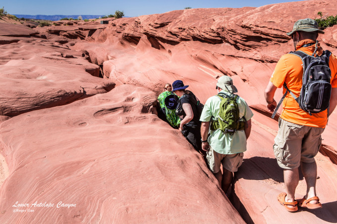
Following the tour guide, all first-time visitors will file into this rocky crevice like an earthworm with a skeptical mood.
The Lower Antelope Canyon is called Hasdestwazi by the local Navajo people, which means “spiral rock arch”, and the entire visiting passage is located below the canyon bed surface. When we walked step by step along the fixed iron ladder to this slightly open area, the gap that was lying on the rock like an earthworm has now become a skylight for lighting the entire visiting route. The amazing starts here. .
Antelope Canyon does not have any artificial lighting! The light that everyone sees now is the light of the “skylight” at the top of the canyon. After the repeated refraction of the rock texture and entering the bottom of the canyon, dreamy and irregular color changes are produced in the middle, and the rocks with clear lines and different shapes are also accompanied by these changes. The light is endlessly changing, and it is really hard to believe that these changing lights come from a single natural light source unless you are there yourself.
Antelope Color Cave is formed by soft sandstone through various erosions. It has experienced repeated scouring of flash floods in the long history of millions of years. Especially in the rainy season, the flash floods generated by the vast basins violently flow into the canyons, entraining them. Repeatedly pounding in the narrow canyons with sand. Over time, the sandstone on the inner surface of the channel is eaten away, leaving an unpredictable “flow” imprint on the deeper rock.
The original meaning of Canyon in English is the consciousness of the canyon, but because Antelope Canyon itself has the characteristics of natural color changes, the Chinese translation of this place as Antelope Canyon is a very relevant nickname. Antelope Canyon is divided into two unconnected scenic spots, Antelope Canyon and Lower Antelope Canyon. The straight-line distance between Antelope Canyon and Lower Antelope Canyon is less than 10 kilometers.
The best time to photograph the Lower Antelope Canyon is in the early morning and evening. During this time, the unique lighting effects in the canyon will make you feel amazing everywhere, and the changing colors can also leave everyone with amazing memories.
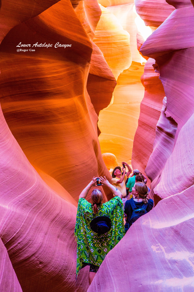
Indians are a multi-talented people. In addition to their excellent handicrafts, their singing and traditional wind music are also extraordinary. When the handsome guide played the flute in the eerie light of the canyon , the passengers were not only intoxicated by the melodious sound of the wind music, but also shocked by the modeling effect in front of them. Everyone held their breath involuntarily and picked up the cameras in their hands to capture these scenes that could only be reproduced in movies.
Looking up along the ladder near the exit, the light outside the canyon becomes more and more intense. Although the shape and texture of the rocks in the canyon are still changing, the color changes will gradually become dull.
Antelope Canyon is one of the most famous slot canyons in the world. It is located next to Page town in the Lake Powell area of Arizona, USA. The Antelope Canyon is also a photographer and a photographer. It is a popular spot for tourists and enjoys the reputation of a photography mecca. Here, whether you come here for the first time or come again to seek your dreams, I believe that Antelope Canyon will bring you an amazing surprise that will never be covered!
Lake Powell National Park
Lake Powell National Park (Lake Powell National Park) is a reservoir formed when the Glen Canyon Dam was built from 1956 to 1966 and named Lake Powell after the explorer General John Wesley Powell, with a total area of 4,856 square kilometers. The second largest artificial lake.
Because of the eroded landform, the two sides of the lake twist and turn, making the lake shoreline 3,200 kilometers long, which is longer than the coastline of the entire Pacific coast of the western United States. There are 96 canyons of various shapes in the scenic area. Since the establishment of the water recreation center in Lake Powell in 1972, it has received as many as three million tourists from all over the world every year.
The best way to see and taste Lake Powell is by luxury yacht, from Antelope Point Marina to Rainbow Bridge : $125.00 per person!
When we bought tickets and boarded the cruise ship, we found that the cruise ship with more than 100 people had been fully arranged. Although it was still a cool day at this time, the uncovered seats on the upper deck of the cruise ship were the best choice for tourists to board the ship first, and then board the ship. The tourists on the boat can only enjoy the shade in the seats on the bottom floor.

Rainbow bridge
Visitors need to take a boat from (Antelope Point Marina), pass the end of Lake Powell, and walk for 45 minutes along the mountain path next to the dry riverbed to get a close look at the Rainbow Bridge.
Lake Powell is surrounded by countless strange peaks and rocks, especially the Rainbow Bridge (Rainbow Bridge), which is regarded as a holy bridge by the local Indians, making the place a fascinating place for wild adventures in the west.
Rainbow Bridge The largest naturally formed arch bridge in the world. The bridge is 290 feet (88 meters) high, almost the same height as the Statue of Liberty in New York. The top of the arch bridge is 33 feet wide and 42 feet thick. The arch bridge spans 275 feet and sits like a beautiful rainbow in a quiet corner of Lake Powell.

[Chinese Tour Guide]
There are Chinese travel guides specially printed by the National Park Service at the entrances of most national parks in the United States. The tickets themselves already include the cost of these Chinese and English travel guides. Friends in need can visit the park entrances. It is free from the administrator, and the tourist guide does not need to bear any other costs.
Bryce Canyon National Park
Bryce Canyon National Park is a national park located in southwestern Utah, United States. Huge natural amphitheater created by erosion. Its unique geographic formations, called hoodoos, are made up of wind, water and ice erosion in rivers, and sedimentary rocks from lake beds. The red, orange and white rocks in it form a peculiar natural landscape, so it is known as the palace of natural stone figurines.
First impressions of Bryce Canyon are dramatic, with a semicircular rock basin like a “natural amphitheater”. Some of these living dragon sculptures stand in rows, some sit, and some lean against each other. In this giant amphitheater, they are all consistently performing their own unique roles. You can see their faces as clearly as they were before they turned into rocks. This is the “Nature Amphitheatre” of Bryce Canyon. The charm of it!

Rock Pillar
The hoodoos are the main visiting items for tourists in Bryce Park. The hoodoos are a kind of sedimentary rock formed by the accumulation of wind, sand, water and the lake bed. The columns will display a magnificent view of different colors, and the red, white, orange and pink rock columns are especially fantastic and eye-catching, and they are also the most common colors in the canyon.
The rocks of Bryce Canyon have been eroded by flowing water and ground by mudslides thousands of years ago. All the rocks look strange, with scratches and deep marks in impossible places, permeating a strange atmosphere.
Walking in the canyon, the majestic momentum of the stone pillars is breath-taking. When we look up and look into the distance, some stone pillars seem to be swords that go straight into the sky, some are like camels, some are like a terracotta warrior of the Qin Dynasty, and some are like In the Jinluan Hall, there are hundreds of civil and military officials standing respectfully, some are like ancient temples, some are like ancient women in a bun, and one is isolated and independent, like an empress wearing a crown.

Valley Bottom
If time permits, you should walk down the trail to the bottom of the valley, and watch the stalagmites that are inserted into the sky. This is a reserved program that photography enthusiasts will not miss. It’s a pity that when I came here this time last year, I only wore A pair of flat-bottomed walking shoes, after slipping several times on the steep trail, faced the cliff without the protection of the railings, and finally reluctantly chose to give up the original intention of walking down to the bottom of the valley, so this year, I came prepared and put on After wearing non-slip hiking shoes, I finally got a taste of my wish to step into the bottom of the valley.
This magical land in Utah was formed by 3 billion years of wind and sun. It became a U.S. National Reserve in 1924, and officially became a national park in 1928. Walking in this 145-square-kilometer canyon is very beautiful. It is easy to get lost, either because of this intricate landform, or because of this fascinating natural scenery.

Canyonlands National Park
Canyonlands National Park is located at the confluence of the Green River and the Colorado River in southeastern Utah, USA. It is known to the world for its sinister peaks and rugged rocks.

Mesa Arch
Looking at the vast fields and ravines, cracks and snow-capped mountains through the Mesa Arch is a rare visual enjoyment.
Mesa Arch is the most famous scenic spot on the high-altitude island. It is the commanding height of this high altitude. Mr.Harry, who was walking with us, regarded thousands of ravines as flat ground. His Chinese kung fu is not only in this span. The natural arch over 10 meters is famous all over the world. It even made the other Western heroes present had to resign.
The topography of Canyonlands National Park is different from nearby national parks. Imagine that a flat highland suddenly sinks into the ground to form thousands of ravines. The river runs through the thousands of ravines and forms countless canyons, which is very strange.
Canyonlands National Park covers a vast area, and the landscape is vast and boundless. In the park, there are terraces, canyons and other landscapes named according to their shapes, colors and various characteristics, such as the Golden Ladder, Elephant Gorge, Devil’s Peng, Tianxian Island, Doll Stone, Tapestry Stone, Horseshoe Valley, as well as spectacular terraces and rocks. array etc. Animals include deer, foxes and coyotes. It is a huge, open and closed wilderness scenery. There are no roads here. The so-called roads are all trails that can only be passed by four-wheel drive off-road vehicles. It is recognized as one of the most inaccessible areas in the United States.
The south of the canyon is called the Needle Point Scenic Area, and the westernmost side is called the Labyrinth Scenic Area. These areas all share a pristine desert atmosphere, and each area has its own characteristics. The Colorado and Green Rivers flow through the Colorado Plateau, cutting it into many canyons. The park has sandstone towers and canyons that have been eroded by rivers and wind, frost, rain and snow for many years, making it one of the most famous erosion areas in the world. Due to its spectacular erosion, Canyonlands National Park is known as a “Museum of Natural Geology”, a place for hikers to challenge themselves and one of the few parks in modern American civilization.
Among the many national parks in the western United States, [Canyonland National Park] is not well-known. It is not as beautiful as [Bryce Canyon National Park], and it is not as world-famous as [Grand Canyon National Park]. , not as well-known as [Yellowstone National Park], but the canyon land, with its own unique wild scenery, is more and more burning the enthusiasm of Americans to challenge the difficulty of entering.

Arches National Park
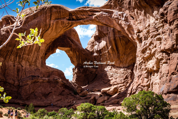
Arches National Park, located in Utah, USA, is one of the largest concentrations of natural sandstone arches in the world, preserving more than 2,000 natural rock arches, including the world-renowned Delicate Arch.

Park Avenue
Soon after entering the park, you can see Park Avenue (Park Avenue) on the roadside, its name comes from the avenue of the same name in New York, because the avenue in New York is lined with high-rise buildings. I saw that there were “high-rise buildings” on both sides of the passage that was about a mile long and about a hundred meters wide, and the boulders stood there straight up and down. After that, you can also see two more famous attractions on the road, Courthouse Towers and Balanced Rock. This is Arch Park.
Experts believe that water, ice, extreme temperature changes and the movement of underground salt are the main reasons for the special rocky landscape of Arches National Park. To this day, new arches continue to be “manufactured”; conversely, old arches are slowly collapsing toward destruction. This geological wonder is called “the art of God”.
There are not only arches in the park, but also a large number of large and small spires, pedestals and balancing stones and other peculiar geological features; all the stones in the Arches National Park are textured with very contrasting colors. The stone is formed because 300 million years ago there was a vast ocean here, and after the water disappeared, many years passed, and the salt bed and other debris were squeezed into the rock and became thicker and thicker. After that, the bottom of the salt bed was crushed by the pressure above, and after the uplift of the crust, coupled with weathering and erosion, one by one arched stones were formed.
Double Zero Arch
The Double O Arch, which consists of two arches of the same size intertwined, is a great spot for many sunrise photography.

Delicate Arch
The mountain where the Delicate Arch is located is not too high. It takes about 2 miles to walk from the parking lot to a rugged mountain road. Because of the rocks everywhere, the road is difficult to walk. One hour of physical strength and drinking water is required for each trip. The arch is at the top of the slope, and there are a series of pyramid-like pinnacles lined up nearby. From a distance, it looks like a camel caravan is heading towards the arch. Delicate Arch is the treasure of the town park of Arches National Park and the symbol of Utah. Its image is printed on the license plates of Utah. When the torch of the 2002 Winter Olympics was passed, it was specially arranged to pass under the Delicate Arch.
The exquisite arch is as high as 20 meters, and a 6-story building can be built under it, which shows its majesty and tallness. It is indeed very delicate, with the arch column on one side firmly “stepping” on a flat stone surface, and the other side of the arch drooping gracefully, gently kissing a rising stone below. From a distance, this elegant arch looks like a pair of gigantic trousers, which has earned it the nicknames “School Trousers,” “Old Virgin Bloomers,” and “Cowboy Leather Pants.”

Landscape Arch
The Landscape Arch is 93 meters long, the largest span among the more than 2,000 arches in the park, and the longest natural arch in the world. Its thinnest point is only 1.8 meters, and its shape is like a slender belt. , may collapse at any time.
It is said that in the 1990s, a few tourists were sitting under the arch to rest when they suddenly heard a loud noise like thunder. As the original giant arch naturally peeled off, a new arch as thin as a blade appeared in front of people’s eyes. As a precautionary measure, since then, the park management has banned visitors from going under the arch and has fenced it off with railings. Because this arch is subject to new collapses at any time, there is reason to believe that the world’s longest arch will eventually disappear in front of people’s sight!
Yellowstone National Park
Yellowstone National Park, referred to as Yellowstone Park, is located in the northwest corner of Wyoming in the Midwest of the United States, covering an area of 8,956 square kilometers. Founded in 1872, it is the world’s first national park and was listed as a World Natural Heritage in 1978.
Yellowstone National Park is a famous tourist destination. In the early 20th century, an American explorer once described Yellowstone Park in this way: “In different countries, no matter how different the scenery and vegetation are, Mother Earth is always so familiar, kind, and eternal. But here, The earth has changed so much, as if this is a place belonging to another world. . . The earth seems to be testing its infinite creativity here.”
It is a hotbed of geothermal activity, with more than 10,000 geothermal features; the Rocky Mountains have created countless beautiful mountains, rivers, waterfalls and canyons for this territory, and its limestone structure adds beautiful colors to the earth; Numerous wild animals give it endless life. This is the home of the Wyoming herd and the largest and most diverse mammal habitat on land in North America and the world.
In Yellowstone’s hot springs, trillions of bacteria, the most primitive forms of life on Earth, form mats of odd shapes. Flies and other arthropods live on these mats, even in harsh winters. At first scientists thought that microbes could only get their nutrients from sulfur, but in 2005 researchers at the University of Colorado Boulder discovered that at least some hyperthermophilic species can also get their energy from hydrogen molecules.
The unique natural scenery of Yellowstone Park shows the mighty power of nature. Over the past 60 million years, the volcanic eruptions in the Yellowstone area have formed a lava plateau with an altitude of more than 2,000 meters in the 21st century, plus three glacial movements, leaving valleys, waterfalls, lakes, and groups of hot springs and fountains. Nature has carefully crafted water, fire, ice and wind here, arranging the enchanting scenery. To travel the mountains, there are three sides of the east, west and north, the peaks are ups and downs, there are canyons between the mountains, the roads are bumpy, and the mountains are rocky; Cascading down from the clouds, some rushing out of the valley, some emerging from the ground; to see the animals, there are waterfowl, birds and wild mammals – elk, black bear, moose and bighorn sheep. According to data, Yellowstone National Park is the largest wildlife sanctuary in the United States.

Mammoth Hot Springs
As the crust changes, places that were very active may suddenly quiet down; places that were previously unknown may also be a blockbuster. The Mammoth Hot Spring in the northwest corner of the park is an example: it turned out to be several hot springs flowing down the hillside section by section, dyed colorful by various bacteria, forming a very beautiful large step; However, due to a crustal change in 2002, most of the hot springs here no longer flow, and the dead bacteria turned into gray-white powder, which remained on the large dry steps, reflecting the dazzling sunlight, turning this place into a gray-white powder. A barren, barren land.

yellowstone canyon
The Yellowstone Canyon is located between the fishing bridge and the tower. The river water flowing out of the Yellowstone Lake flows through the steep canyon caused by the area of about 38 kilometers, which is commonly known as the Yellowstone Grand Canyon. Here is the most magnificent and gorgeous scenery in Yellowstone Park. The 97-kilometer-long Yellowstone River is “the only river in the United States without a dam”. Here, the river suddenly became turbulent, rushing out the splashes, forming two magnificent waterfalls, roaring the grand canyon. One of these two waterfalls is 130 meters high, which is the upper waterfall; the other is 100 meters high, which is called the lower waterfall.
Summer is the most suitable season for tourism in Yellowstone Park. In summer, the temperature in Yellowstone Park reaches about 25 degrees Celsius during the day, and it can reach 30 degrees in some low areas. It’s usually cool at night, but the highlands sometimes drop below zero, and the river winds that accompany storms often come unexpectedly. In winter, daytime temperatures range from minus 20 to minus 5 degrees. The lowest temperature recorded was minus 54 degrees. Snowfall is heavy, averaging 150 feet. In addition, travelers traveling to Huangshi also need to pay attention to the temperature difference between day and night, and make relevant preparations.

Mount Rushmore National Memorial
Mount Rushmore National Memorial, commonly known as U.S. Presidential Park, U.S. Presidential Mountain, and Presidential Statue Mountain, is a United States Presidential Memorial Park located near Keystone, South Dakota, United States. Memorial).
There are four 60-foot-high (about 18 meters) portraits of famous former presidents in the history of the United States. They are Washington, Jefferson, Roosevelt, and Lincoln. These four presidents are considered to represent the history of the United States since its founding 150 years ago. The entire park covers an area of 1,278 acres (5.17 square kilometers), and the highest point is 5,725 feet (1,745 meters) above sea level. The park is managed by the National Park Service, a branch of the U.S. Department of the Interior, and attracts about two million tourists each year.
Today, Mount Rushmore is not only a world-class tourist destination, but also a symbol of the President of the United States in American culture. At the same time, under the influence of contemporary popular culture, Mount Rushmore has also derived many other meanings.

Niagara Falls
Niagara Falls (Niagara Falls) is located in the middle of the Niagara River at the junction of Canada and the United States. With an average flow of 5,720 cubic meters per second, it is the world’s largest transnational waterfall.
Niagara Falls is considered to be one of the most spectacular scenery in the world, and together with Iguazu Falls and Victoria Falls, it is known as the three major transnational waterfalls in the world. Niagara Falls has always attracted people to honeymoon, tightrope across the falls or barrel drift.
The abundant and vast water vapor and majestic momentum of Niagara Falls, listen to its sound like thunder and lightning, and watch its momentum as overwhelming! Whether at the bottom of the lake basin or deep in the heart of the waterfall, or standing in the spray on the edge of the huge horseshoe-shaped cliff with a drop of about 13 stories, all visitors who come to watch it are shocked.
Niagara Falls is a magnificent three-dimensional picture, which can be viewed from different angles and have different feelings. Facing the Great Falls, people swayed their minds, and in this earth-shattering masterpiece of nature, a little bit of uprightness was added, and a little bit of wretchedness was reduced.
“Niagara Falls” is also literally translated as Lagko or Nicaragua Falls. “Niagara” means “water of Thor” in Indian language. The Indians believe that the roar of the waterfall is the voice of Thor speaking. Before they actually saw the waterfall, they heard what sounded like a continuous thunderstorm, so they called it “Onguiaahra” (later Niagara), which means “huge mine”.
There are different ways to see this different waterfall, but the most special one is to take the Mist Maid sightseeing boat, put on a waterproof tool to visit under the waterfall, shuttle between the turbulent waterfalls, to the confusing waterfall In the mist, the sound of the waves is thrilling, and the mist and water wash away the noise.
The United States and Canada have always attached great importance to the tourism development of Niagara Falls. By the 1820s, Niagara Falls had become a tourist destination. On May 24, 1888, Niagara Falls Park officially opened to the public. In addition to establishing a tourist city of Niagara Falls for the development of tourism, as early as 1885 when Canada was founded, the Canadian government established the Niagara Parks Management Committee, which is responsible for protecting the natural and cultural relics in this area and planning scenic spots. The Ontario government also nationalized 3,000 acres of land near Niagara Falls for the construction of tourist facilities.
Summer is undoubtedly the best time to watch Niagara Falls. At this time, it is the rainy season, and the flow of the waterfall reaches the largest level of the year, which is naturally the most magnificent time.
The waterfall always welcomes all visitors with an open heart. The cruise ship is slightly close to the waterfall, and it is greatly swayed by the falling water waves. The storm-like water droplets will hit the head and the face, and the turbulent water is like thousands of horses, thrilling, At this time, no matter how good the raincoat is, it cannot resist the hospitality of the waterfall, and all the passengers will cheer excitedly with the thunderous sound of water. This is not so much a viewing of the waterfall as it is to experience the waterfall in person. The cruise ship shuttles through the thousands of layers of water vapor aroused by the waterfall. From the shore, it really looks like a “girl in the fog”.
After the end of the local rainy season in mid-June every year, Niagara Falls is full of water and the local weather is fine. The water mist stirred up by the waterfall makes rainbows visible everywhere in the entire waterfall area under the sunlight. This period is called Niagara Falls by locals. During the rainbow season, you can see beautiful rainbows nestled next to the majestic waterfall, forming a wonderful landscape.
When the red sun falls, the bead-like water splashes of Niagara Falls, under the setting sun, the colorful rainbows are splendid and eye-catching. Under the illumination of colorful lights, the magnificent waterfall during the day becomes more crystal clear and shining.

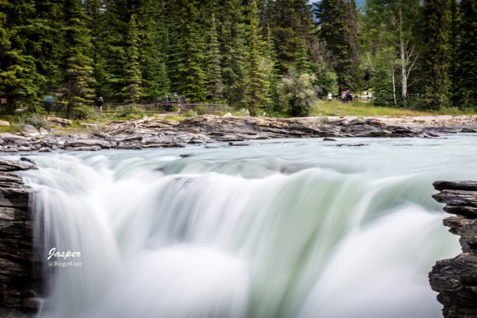
Jasper National Park
On the way from Jasper National Park to Banff National Park (Banff National Park), you will definitely pass this walk along the Rocky Mountains, known as Canada’s most beautiful road – Icefield Parkway ( Icefields Parkway, i.e. Route 93). This Icefield Avenue, which starts from Lake Louise in the south and ends in Jasper Town in the north, stretches for 229 kilometers, and the scenery along the way is infinite. We will visit the most classic scenic spots in the Rocky Mountains one by one.

Whistler Hill
The Whistlers Mt (The Whistlers Mt) is located about 7 kilometers southwest of Jasper Town, with an altitude of 2464 meters. To visit Whistler Mountain, you can take the Jasper Tramway, which can accommodate 30 people and reach the observation deck at the top of the mountain within 7 minutes. Climb up another 1km along the observation deck trail to see snow-capped peaks and the Columbia Icefield.

Jasper cable car operation time:
late April-late June and late August-late September 9:30-18:30;
early July-mid-August 8:30-22:30
Fee: 19 Canadian dollars for adults; $9 for children
Jasper Natioal Park is one of Canada’s famous alpine national parks and the largest national park in the Canadian Rockies. The park is located in the northernmost part of the Rocky Mountains in Alberta, covering an area of 10,878 square kilometers. Beautiful, beautiful environment, with a variety of wildlife, such as red deer, fawn, goats, moose, bighorn sheep, Asiatic black bear, American black bear, beaver, Rocky Mountain pika, marmot and caribou than the local population more residents.
Medicine Lake
Medicine Lake, also known as Magic Lake, is the most mysterious lake in the Canadian Rockies, disappearing once a year. The water level is affected by the underground river system and varies from time to time. The water level changes continuously in different seasons every year: from spring to summer, the glaciers melt, and the lake is full; in autumn, the amount of snow melted on the mountain decreases, and the water level begins to drop until the winter is completely complete. When it dries up to the bottom, the entire lake disappears. And in the spring and summer of the coming year, the lake water will come as promised, and so on and so forth.
At the tourist information office in Jasper Park, visitors can inquire about detailed hiking routes, and can also apply for excursions to remote areas in the park, but they must purchase a remote area permit, which costs 6 Canadian dollars per person per day, the most You can apply for up to 5 days. In addition, fishing, canoeing, horseback riding, etc. are also popular leisure methods for tourists.

Maligne Lake
Maligne Lake is the largest glacial lake in the Canadian Rockies, about 22 kilometers from north to south, about 1 kilometer from east to west, and has a deepest point of 27 meters. The most famous here is the mysterious Elf Island. This Elf Island at the end of Maligne Lake was originally unknown. It won a photography award in the 1950s based on a photo taken by a local photographer on Elf Island, and was frequently selected for various It became famous for its albums and became a must-see for tourists in one fell swoop.
The Canadian Rockies show the world the majestic mountains with staggered peaks, scenic national parks, lakes scattered like pearls, charming towns and vast wilderness – the magnificent scenery has attracted countless photographers. lens. Here, visitors can get in touch with nature in the most diverse and varied ways: horseback riding, hiking, skiing, biking, canoeing, rock climbing, or a gondola ride.
The staff of the national park will set up some mobile publicity points in places with dense tourists to popularize the common sense of environment and animal protection to tourists for free. like.
From the town of Jasper, follow Maligne Lake Road to Maligne Lake. First came Maligne Canyon. There are 6 bridges along the canyon, the deepest point is 55 meters, the narrowest point is only 1 meter, and the length is about 2 kilometers.
The most surprising is the waterfall located on the second bridge. This waterfall with a drop of 50 meters down the rapids has exerted the magical power of water droplets and stone penetration. After a long period of unremitting efforts, it seems to be hard. The incomparable rock was ground into an incomparably smooth pothole, and then roared down the torrent with a strong eddy current.
Maligne Canyon
The highlight of Marlene Canyon is standing on the bridge overlooking the rushing rapids below the canyon and witnessing how she walks thousands of miles in the cold rock wall without looking back.

Columbia Icefield
The Columbia Icefield is the world’s largest ice remnant outside the Arctic Circle. Due to the high density of the ice layer of the glacier, sunlight cannot be refracted, and it will show a crystal clear blue light, which is very magnificent under the clear sky. From this, the melting snow flows to the Pacific Ocean, the Atlantic Ocean, and the Arctic Sea, which is a natural treasure formed after four ice ages.
The authorities equate the influence of the Colombian ice sheet with the Great Wall of China and the pyramids of Egypt, and it is a must-see item for tourists to the Rocky Mountains. A glimpse of the Athabasca Glacier has become an indispensable life experience.

Icefield Centre Icefield Centre Snowcoach
Tel: 001 877 4237433
Opening Hours: May-October 9:00-18:00 (every 15 minutes)
Fee: Adult 30 CAD / Child 15 CAD
Banff National Park
Banff National Park was established in 1885 and is located 100-130 kilometers west of Calgary, Alberta, Canada, and is the gateway to the Rocky Mountains. The entire National Park covers an area of 6,641 square kilometers, including the charming towns of Banff and Lake Louise. There are valleys and mountains, icefields and rivers, forests and grasslands, and it is a world-class tourist destination.
The first thing to do when you come to Banff is to take the Banff Gondola, which is an unparalleled panoramic impression of Banff. The cable car is a four-seater. Through the glass windows of the high-speed cable car, you can have a bird’s-eye view of the beautiful mountain scenery. After reaching the top of the 2,285-meter-high Sulphur Mountain in about 8 minutes, you can have a panoramic view of Banff, Bow River Valley, Minnewanka Lake, etc. Breathtaking views overlooking the majestic Rocky Mountains. If you have leisure time, you can also enjoy the food of the highest restaurant in North America on the top of the mountain.
The park has famous landscapes such as Lake Louise, Morain Lake, Columbia Icefield, as well as hundreds of animals. The park offers a variety of activities, including canoeing, boating, horseback riding, hiking, skiing, snowmobile tours, etc. It attracts millions of tourists from all over the world to visit here every year.
In April 1999, when our Prime Minister visited Alberta, he temporarily changed his itinerary to visit Banff National Park in the rain. It can be seen that the charm of Banff is extraordinary.
Banff National Park is Canada’s first and the world’s third national park and is listed as a World Heritage Site by UNESCO. In 2010, among the Canadian outdoor adventure destinations selected by users of TripAdvisor, the world’s most popular travel review website, Banff National Park topped the list; at the same time, Banff ranked No. Four.

Sulphur Mountain
About a kilometer west along the ridge trail, there is a weather station built in 1903. During the walk, you can enjoy the magnificent scenery from different perspectives. Standing on the top of the mountain sightseeing rooftop feels like being on top of the world. Whenever the sun rises and the sun sets, the pink sunlight reflects on the snow-capped peaks of the towering Rocky Mountains, which is intoxicating. The Brewster Sulphur Mountain Banff Aerial Tram is a must-see when visiting Banff National Park.

Banff Springs Hotel
A century ago, the Trans-Canada Pacific Railway was built. General Manager William Cornelius Van Horne, in order to realize the plan of driving the passenger train industry with tourism, started a large-scale construction project along the Canadian Pacific Railway. Built a series of luxury hotels, Banff Springs Hotel is one of them. For more than 100 years, the hotel has been nestled among the majestic Rocky Mountains, and at its foot lies the clear Bow River, known as the “Castle in the Rocky Mountains”.

lake minnewanka
Lake Minnewanka is the largest and deepest lake in Banff National Park, located east of Banff, about a 15-minute drive. Its name is derived from the Indian Stoney, meaning “water spirit”. The Minnewanka Valley is home to many wildlife, surrounded by beautiful scenery and unique rocks.

Lake Louise
Lake Louise is derived from the Victoria Glacier. The lake is green and clear, and it looks like an emerald inlaid in the Rocky Mountains from a distance. The lake is extremely cold. If you are boating on it, you might as well reach into the lake and feel it gently. Every year from November to June of the following year, the lake will freeze, and the snow will be white, integrated with the snow and ice of Mount Victoria, making it a scenic ice skating rink.
The best time to visit or photograph Lake Louise is in the early morning, when the lake is unusually calm and relatively few tourists. If you are lucky, you can also take photos of Jinshan. If you like to hike, follow the lakeside trail to the west side of the lake, which is a great place to photograph Lake Louise and the Castle Hotel. However, because of the light, it is better to take pictures on the west side of the lake in the afternoon.
Surrounded by dense forests, Lake Louise is as clear as a pearl, with ice muscles and jade bones, and it is otherworldly. She uses the graceful Victoria Mountain as a barrier, and the mountains and rivers are interdependent, forming a picture that painters and photographers dream of.
